IMAGES TAKEN NEAR TO
Poplar Road, BATH, BA2 2AJ
Introduction
This page details the photographs taken nearby to Poplar Road, BA2 2AJ by members of the Geograph project.
The Geograph project started in 2005 with the aim of publishing, organising and preserving representative images for every square kilometre of Great Britain, Ireland and the Isle of Man.

There are currently over 7.5m images from over14,400 individuals and you can help contribute to the project by visiting https://www.geograph.org.uk
Image Map
Images are licensed for reuse under creativecommons.org/licenses/by-sa/2.0
Notes
- Clicking on the map will re-center to the selected point.
- The higher the marker number, the further away the image location is from the centre of the postcode.
Image Listing (30 Images Found)
Images are licensed for reuse under creativecommons.org/licenses/by-sa/2.0
Image
Details
Distance
1
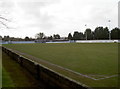
Odd Down football ground
The Toolstation Western League club was formed in 1901 and play here at the Lew Hill Memorial Ground. The club moved to this ground in the 1930s, purchasing it outright in 1952, and have named it after one of their presidents.
Image: © Neil Owen
Taken: 17 Jan 2018
0.06 miles
2

Burnt House Road play area
A little play area on the edge of the new housing estate. The Burnt House refers to an old eighteenth century farm house that used to exist a short distance away on the Wellsway. It served as a brewhouse and inn from about 1870 up until its closure in 2006. The inn was demolished and flats now stand on the site.
Image: © Neil Owen
Taken: 17 Jan 2018
0.06 miles
3
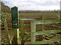
Manor Farm permissibles
The old estate has largely been given over to agriculture, although some of the land is now planted with trees and some permissible paths are offered to walkers.
Image: © Neil Owen
Taken: 17 Jan 2018
0.09 miles
4

Combe Hay Lane
Meeting Sulis Manor Road at a T junction. It does form an offset crossroads; to continue along Combe Hay Lane you turn right and left. On the far side is a glimpse of The New Sixth.
Image: © Derek Harper
Taken: 16 Feb 2016
0.13 miles
5

One stone on top of another
Some slow-paced construction on site today.
Image: © Neil Owen
Taken: 17 Jan 2018
0.16 miles

7
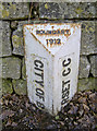
Disappearing under the leaves
A boundary marker of over a hundred years stands a little lower on the road surface these days. It's interesting to note how the current boundary is now defined as Bath an North East Somerset - whereas Bath and Somerset were separate in the past. See Image] for a wider view of more markers.
Image: © Neil Owen
Taken: 17 Jan 2018
0.17 miles
8

Where the Wansdyke and the Fosse Way meet
A crossroads of ancient carriageways here in the south of Bath: the Roman road and the ditch works converge around this point. Such a prominent landscape feature inevitably attracted the attention of the planners and administrators, as witnessed by the boundary markers of various ages. See Image] for a closer look at the white one.
Image: © Neil Owen
Taken: 17 Jan 2018
0.17 miles
9

2008 : Marker post of the Bath Turnpike Trust
The word "Bath" has been obscured by roadworks. The distances are approximately 2 miles to Widcombe and 1 1/2 miles to Combe Hay.
Image: © Maurice Pullin
Taken: 10 May 2008
0.17 miles
10
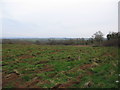
Farmland off Combe Hay Lane
A view looking to the south across farmland off Combe Hay Lane.
Image: © Phil Williams
Taken: 8 Mar 2007
0.17 miles