IMAGES TAKEN NEAR TO
Sutton Bingham, YEOVIL, BA22 9QN
Introduction
This page details the photographs taken nearby to BA22 9QN by members of the Geograph project.
The Geograph project started in 2005 with the aim of publishing, organising and preserving representative images for every square kilometre of Great Britain, Ireland and the Isle of Man.

There are currently over 7.5m images from over14,400 individuals and you can help contribute to the project by visiting https://www.geograph.org.uk
Image Map
Images are licensed for reuse under creativecommons.org/licenses/by-sa/2.0
Notes
- Clicking on the map will re-center to the selected point.
- The higher the marker number, the further away the image location is from the centre of the postcode.
Image Listing (33 Images Found)
Images are licensed for reuse under creativecommons.org/licenses/by-sa/2.0
Image
Details
Distance


3

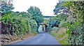
Isles Lane near Sutton Bingham
Isles Lane takes walkers and riders from Hyde Farm towards Isles Farm and Sleight Plantation.
Image: © Maigheach-gheal
Taken: 5 Aug 2011
0.10 miles
4

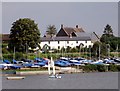
The Sailing Club, Sutton Bingham
Image: © Michael W Beales BEM
Taken: 1 Mar 2009
0.13 miles
5

Sutton Bingham Reservoir and sailing club
Image: © Jonathan Thacker
Taken: 14 Sep 2017
0.15 miles
6

Old Direction Sign - Signpost near Pincushion Corner, East Coker parish
Lost finial - 3 arms; Somerset SCC pyramid by the UC road, in parish of East Coker (South Somerset District), near Pincushion Corner.
Surveyed
Milestone Society National ID: SO_ST5511A
Image: © Milestone Society
Taken: Unknown
0.15 miles
7
Sailing club and old railway cottages Sutton Bingham
The railway line runs alongside the cottages and the reservoir for a few hundred yards before entering a cutting near Netherton Bridge. The roofs of Hyde Farm and its barns can be seen behind.
Image: © Sarah Smith
Taken: 30 Aug 2008
0.16 miles
8
Site of former Sutton Bingham station
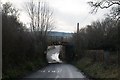
View southward down towards Sutton Bingham Reservoir (out of sight), under the bridge carrying the ex-LSWR (London etc.) - Salisbury - Yeovil Junction (to left) - (to right) Exeter main line. The station had been on the left, closed 31/01/62.
Image: © Ben Brooksbank
Taken: 6 Sep 2013
0.16 miles
9

No sailing today at Sutton Bingham Reservoir
The reservoir has been drained to allow strengthening of the dam (in the next grid square) which can be seen in the distance on the right. This is presumably after all the flooding in other parts of the country last year and concerns about dams failing. The causeway carrying the road and the bottom of the dam have been exposed> The sailing club is high and dry.
Image: © Nigel Mykura
Taken: 2 Jan 2008
0.16 miles