IMAGES TAKEN NEAR TO
East Coker, YEOVIL, BA22 9QJ
Introduction
This page details the photographs taken nearby to BA22 9QJ by members of the Geograph project.
The Geograph project started in 2005 with the aim of publishing, organising and preserving representative images for every square kilometre of Great Britain, Ireland and the Isle of Man.

There are currently over 7.5m images from over14,400 individuals and you can help contribute to the project by visiting https://www.geograph.org.uk
Image Map
Images are licensed for reuse under creativecommons.org/licenses/by-sa/2.0
Notes
- Clicking on the map will re-center to the selected point.
- The higher the marker number, the further away the image location is from the centre of the postcode.
Image Listing (12 Images Found)
Images are licensed for reuse under creativecommons.org/licenses/by-sa/2.0
Image
Details
Distance
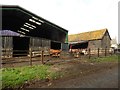
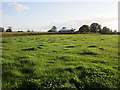
5
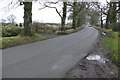
Darvole
Darvole is a large Dairy farm on the Barwick to Sutton Bingham road just south of Yeovil and not far from the A37
Image: © Nigel Mykura
Taken: 29 Jan 2009
0.05 miles
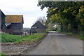
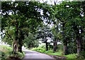
6
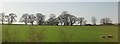
Trees at Darvole
The trees line the ridgetop road from Darvole Farm (its barns can be seen on the right) to Suttin Bingham. View from a train approaching Yeovil Junction.
Image: © Derek Harper
Taken: 29 Apr 2013
0.10 miles
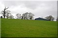
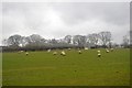
10
The Yeovil Road near Darvole Farm
The road from Halstock to the A37 is lined with Oak trees between Pincushion Corner and Darvole Farm.
Image: © Sarah Smith
Taken: 11 Sep 2008
0.18 miles