IMAGES TAKEN NEAR TO
East Coker, YEOVIL, BA22 9LZ
Introduction
This page details the photographs taken nearby to BA22 9LZ by members of the Geograph project.
The Geograph project started in 2005 with the aim of publishing, organising and preserving representative images for every square kilometre of Great Britain, Ireland and the Isle of Man.

There are currently over 7.5m images from over14,400 individuals and you can help contribute to the project by visiting https://www.geograph.org.uk
Image Map
Images are licensed for reuse under creativecommons.org/licenses/by-sa/2.0
Notes
- Clicking on the map will re-center to the selected point.
- The higher the marker number, the further away the image location is from the centre of the postcode.
Image Listing (15 Images Found)
Images are licensed for reuse under creativecommons.org/licenses/by-sa/2.0
Image
Details
Distance
2
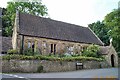
North Coker
Village Hall of this narrow but delightful village.
Image: © Richard Knights
Taken: 10 Jun 2005
0.14 miles
3

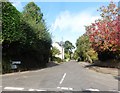
Road north out of Burton
A typical Somerset lane, bounded by high, ivy-clad walls.
Image: © Becky Williamson
Taken: 15 Jan 2015
0.15 miles
4
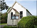
East Coker Christian Fellowship
A charming little wooden building.
Image: © Becky Williamson
Taken: 17 Sep 2014
0.15 miles
6

Lane to Burton
From the crossroads shown in Image
Image: © Derek Harper
Taken: 27 Apr 2019
0.18 miles
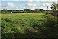
7

Field near Burton
Looking left from where Image] was taken, with overlap.
Image: © Derek Harper
Taken: 27 Apr 2019
0.18 miles

9
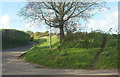
Crossroads near Burton
The lane ahead is for the A30 and Yeovil; it carries the parish boundary between West Coker (left) and East Coker.
Image: © Derek Harper
Taken: 27 Apr 2019
0.19 miles
10
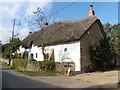
Field by Hunts Cottage
The cottage is on the right, beside the lane to Holywell.
Image: © Derek Harper
Taken: 27 Apr 2019
0.19 miles