IMAGES TAKEN NEAR TO
Burton, YEOVIL, BA22 9LS
Introduction
This page details the photographs taken nearby to Burton, BA22 9LS by members of the Geograph project.
The Geograph project started in 2005 with the aim of publishing, organising and preserving representative images for every square kilometre of Great Britain, Ireland and the Isle of Man.

There are currently over 7.5m images from over14,400 individuals and you can help contribute to the project by visiting https://www.geograph.org.uk
Image Map
Images are licensed for reuse under creativecommons.org/licenses/by-sa/2.0
Notes
- Clicking on the map will re-center to the selected point.
- The higher the marker number, the further away the image location is from the centre of the postcode.
Image Listing (10 Images Found)
Images are licensed for reuse under creativecommons.org/licenses/by-sa/2.0
Image
Details
Distance
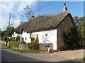
2
North Coker
Village Hall of this narrow but delightful village.
Image: © Richard Knights
Taken: 10 Jun 2005
0.07 miles
3
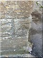
Benchmark on wall of house
Benchmark, very worn, 0.5m above ground level on side of house.
This symbol is used by the Ordnance Survey and other surveyors to pinpoint an exact height above sea level, which is denoted by the horizontal line above the arrow. This provides the standard, "Benchmark," from which all other heights are measured. This bench mark was used for 'levelling' in 1967.
Image: © Paul D
Taken: 10 Oct 2014
0.09 miles
5
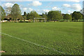
Football pitch, North Coker
The playing field is by Long Furlong Lane.
Image: © Derek Harper
Taken: 27 Apr 2019
0.15 miles
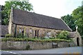
6
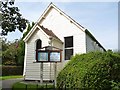
East Coker Christian Fellowship
A charming little wooden building.
Image: © Becky Williamson
Taken: 17 Sep 2014
0.17 miles
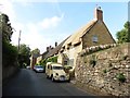
8
Chapel Row, North Coker
A terrace of four seen from Long Furlong Lane.
Image: © Derek Harper
Taken: 27 Apr 2019
0.17 miles
9
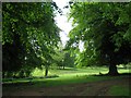
Parkland North Coker
Once belonging to North Coker House, this parkland has majestic lime trees growing in its undulating ground.
Image: © Sarah Smith
Taken: 20 May 2009
0.22 miles
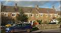
10

North Coker House
Grade II listed and built c1865 in the local stone, North Coker House has now been made into flats. The owner, a one Mr Bullock who went through a series of surname changes through matters of family inheritance from Troyte-Bullock to Troyte-Chafyn-Grove, was a Fellow of the Society of Antiquaries, Justice of the Peace and Deputy Lieutenant.
Image: © Sarah Smith
Taken: 21 Aug 2008
0.24 miles