IMAGES TAKEN NEAR TO
Odcombe Hollow, YEOVIL, BA22 9DW
Introduction
This page details the photographs taken nearby to Odcombe Hollow, BA22 9DW by members of the Geograph project.
The Geograph project started in 2005 with the aim of publishing, organising and preserving representative images for every square kilometre of Great Britain, Ireland and the Isle of Man.

There are currently over 7.5m images from over14,400 individuals and you can help contribute to the project by visiting https://www.geograph.org.uk
Image Map
Images are licensed for reuse under creativecommons.org/licenses/by-sa/2.0
Notes
- Clicking on the map will re-center to the selected point.
- The higher the marker number, the further away the image location is from the centre of the postcode.
Image Listing (34 Images Found)
Images are licensed for reuse under creativecommons.org/licenses/by-sa/2.0
Image
Details
Distance
1
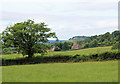
Chinnock Hollow
This is the southern (lower) end of Chinnock Hollow close to East Chinnock village. The holloway proper starts at the trees just beyond the cottage. it is one of the deepest holloways cut through the soft Bridport sands geological formation.
Image: © Nigel Mykura
Taken: 16 Jun 2011
0.02 miles
2
Benchmark, St Mary's Church, East Chinnock
Ordnance Survey benchmark, described on database at http://www.bench-marks.org.uk/bm63568. See also Image]
Image: © Becky Williamson
Taken: 15 Jan 2015
0.04 miles
5
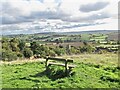
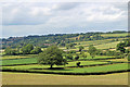
East Chinnock from the Memorial Field and beyond
Although only a short steep walk from the village the Memorial Field commands a panoramic view of the village rooftops and church tower and beyond. It is named the Memorial Field as there are memorial plaques set below planted trees and a white wooden cross. Out of the grid square in question and on the horizon to the left in is Pen Wood near Pendomer and beyond that Corscombe and Winyards Gap in Dorset.
Image: © Sarah Smith
Taken: 10 Oct 2020
0.05 miles
6
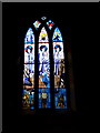
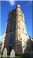
German stained glass window - East Chinnock
The church of St Mary the Virgin is filled with stained glass windows made by a Master Glazier of Leonberg, Stuttgart - Herr Gunther Anton.
During WWII serving in the German Luftwaffe, he was shot down over Southampton and sent to Houndstone Camp, Yeovil, as a prisoner of war. From there he worked on a farm in East Chinnock and attended the church. After the war back in Germany as a recognition of the kind way in which he was treated by the local people in East Chinnock he decided to make the church some beautiful windows. It took him 26 years to complete and he lived to see the dedication in 1989 after which he soon died.
Image: © Sarah Smith
Taken: 23 Oct 2009
0.06 miles

10
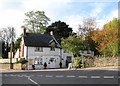
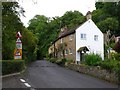
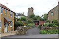
The Gables - East Chinnock
Taken from Carters Lane over the A30. The Gables was originally a bakery in the seventeenth century and the cottages adjoining became the village shop in the 19th century. The house and cottages became a guest house in 1930 and continues today.
Image: © Sarah Smith
Taken: 23 Oct 2009
0.07 miles