IMAGES TAKEN NEAR TO
Orchard Close, YEOVIL, BA22 9BL
Introduction
This page details the photographs taken nearby to Orchard Close, BA22 9BL by members of the Geograph project.
The Geograph project started in 2005 with the aim of publishing, organising and preserving representative images for every square kilometre of Great Britain, Ireland and the Isle of Man.

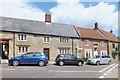
There are currently over 7.5m images from over14,400 individuals and you can help contribute to the project by visiting https://www.geograph.org.uk
Image Map
Images are licensed for reuse under creativecommons.org/licenses/by-sa/2.0
Notes
- Clicking on the map will re-center to the selected point.
- The higher the marker number, the further away the image location is from the centre of the postcode.
Image Listing (62 Images Found)
Images are licensed for reuse under creativecommons.org/licenses/by-sa/2.0
Image
Details
Distance
1
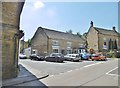
West Coker: the post office
Looking at the frontage of the post office from the shop next door. For some reason the post office is now named West Coker Village rather than plain West Coker.
Image: © Chris Downer
Taken: 24 Jan 2009
0.03 miles
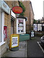
2

West Coker: postbox № BA22 156, High Street
A close-up of the George V-reign 'Ludlow' postbox (named after the designer/manufacturer of this model) which is set into the wall of Image These boxes were designed specifically for sub post offices.
Image: © Chris Downer
Taken: 24 Jan 2009
0.03 miles
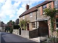
3

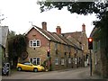
East Street West Coker
One of the main roads of the village this runs east to East Coker.
Image: © Nigel Mykura
Taken: 24 Aug 2011
0.05 miles
4
East St, West Coker
Looking west towards the centre of the village with the High St at the bottom of the hill.
Image: © Nigel Mykura
Taken: 25 Aug 2011
0.05 miles
5
West Coker : Shops on the High Street
Most things in this photo are Grade II listed buildings including the telephone box.
Image: © Lewis Clarke
Taken: 16 Mar 2012
0.06 miles
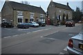
6
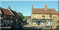
West Coker, village shops
At the village crossroads; left, on the corner, butchers; next to it, post office.
Image: © Mike Faherty
Taken: 19 May 2018
0.06 miles
7
West Coker traffic lights
The High Street (A30) in West Coker reaches its narrowest stretch here in the middle of the village. Nothing can be done about it as the road is lined with old cottages on both sides.
Image: © Sarah Smith
Taken: 10 Oct 2011
0.06 miles
8
West Coker
The junction on the A30 at the heart of the village. The building on the corner housing the East Street Bistro is described at https://www.historicengland.org.uk/listing/the-list/list-entry/1345853 . Also listed is the gate pier on the right https://www.historicengland.org.uk/listing/the-list/list-entry/1177207 .
Image: © Derek Harper
Taken: 26 May 2017
0.06 miles
9
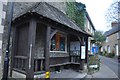
West Coker : Sheltered Seating
A shelter with stone ashlar wing walls with oak corner posts, framework and flat shaped balustrading under cedar shingle hipped roof: erected 1939 to commemorate the life of Sir Matthew Nathan, the village historian, reputedly designed by Sir Herbert Baker. Both have group value contributing to the street scene in the centre of the village.
Image: © Lewis Clarke
Taken: 16 Mar 2012
0.07 miles