IMAGES TAKEN NEAR TO
Church Street, YEOVIL, BA22 9BD
Introduction
This page details the photographs taken nearby to Church Street, BA22 9BD by members of the Geograph project.
The Geograph project started in 2005 with the aim of publishing, organising and preserving representative images for every square kilometre of Great Britain, Ireland and the Isle of Man.

There are currently over 7.5m images from over14,400 individuals and you can help contribute to the project by visiting https://www.geograph.org.uk
Image Map
Images are licensed for reuse under creativecommons.org/licenses/by-sa/2.0
Notes
- Clicking on the map will re-center to the selected point.
- The higher the marker number, the further away the image location is from the centre of the postcode.
Image Listing (67 Images Found)
Images are licensed for reuse under creativecommons.org/licenses/by-sa/2.0
Image
Details
Distance
1
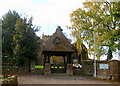
Lych gate - St Martin of Tours West Coker
The lych gate was built in memory of the Reverend William Laurence Cotter. Lych gates were originally built as a temporary shelter for the coffin as it made its way to the church.
Image: © Sarah Smith
Taken: 23 Oct 2009
0.02 miles
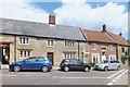
2

The Old Rectory - West Coker
An C18 building that was refaced in Ham stone ashlar early in the C19, and still in use as a Rectory. Grade II Listed.
Image: © Mike Searle
Taken: 24 Jul 2008
0.02 miles
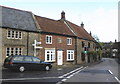
3
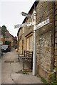
Looking up Church Street from the High Street junction
The building on the right is the pub Inn The Square which has an OS benchmark Image on the base corner stone at the right hand edge of the image
Image: © Roger Templeman
Taken: 24 Sep 2013
0.03 miles
4
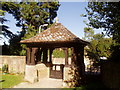
The Church Gate, St. Martin Of Tours, West Coker
Very picturesque gateway, photo taken from inside the church ground.
Image: © Jeanette Rendell
Taken: 27 Aug 2004
0.03 miles
5
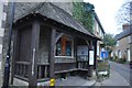
West Coker : Sheltered Seating
A shelter with stone ashlar wing walls with oak corner posts, framework and flat shaped balustrading under cedar shingle hipped roof: erected 1939 to commemorate the life of Sir Matthew Nathan, the village historian, reputedly designed by Sir Herbert Baker. Both have group value contributing to the street scene in the centre of the village.
Image: © Lewis Clarke
Taken: 16 Mar 2012
0.03 miles
6
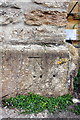
Benchmark on #24 High Street
Ordnance Survey cut mark benchmark described on the Bench Mark Database at http://www.bench-marks.org.uk/bm37112
Image: © Roger Templeman
Taken: 24 Sep 2013
0.04 miles
9
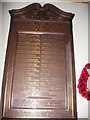
St. Martin Of Tours, West Coker, 1st World War Memorial
This is a plaque on the wall inside the church to remember the people of the village who died for their country in the 1914 - 1918 war.
Image: © Jeanette Rendell
Taken: 27 Aug 2004
0.04 miles
10
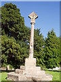
The Memorial at St. Martin Of Tours, West Coker
The memorial is in the church yard at St. Martin Of Tours.
Image: © Jeanette Rendell
Taken: 27 Aug 2004
0.04 miles