IMAGES TAKEN NEAR TO
West Coker Road, YEOVIL, BA22 9AB
Introduction
This page details the photographs taken nearby to West Coker Road, BA22 9AB by members of the Geograph project.
The Geograph project started in 2005 with the aim of publishing, organising and preserving representative images for every square kilometre of Great Britain, Ireland and the Isle of Man.

There are currently over 7.5m images from over14,400 individuals and you can help contribute to the project by visiting https://www.geograph.org.uk
Image Map
Images are licensed for reuse under creativecommons.org/licenses/by-sa/2.0
Notes
- Clicking on the map will re-center to the selected point.
- The higher the marker number, the further away the image location is from the centre of the postcode.
Image Listing (18 Images Found)
Images are licensed for reuse under creativecommons.org/licenses/by-sa/2.0
Image
Details
Distance
1
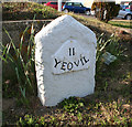
Old Milestone by the A30, West Coker Road, Yeovil
Metal plate attached to stone post by the A30, in parish of YEOVIL (SOUTH SOMERSET District), West Coker Road, West side of petrol station, 80m South West of junction with Camp Road, on the verge, on North side of road. Yeovil roll top iron plate, erected by the Yeovil turnpike trust in the 18th century.
Inscription reads:-
II
YEOVIL
Grade II listed.
List Entry Number: 1417781 https://historicengland.org.uk/listing/the-list/list-entry/1417781
Milestone Society National ID: SO_YVCW02.
Image: © Alan Rosevear
Taken: 27 Apr 2011
0.09 miles
2
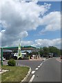
BP filling station, Inglemount, west of Yeovil on A30
Image: © David Smith
Taken: 5 Jun 2014
0.09 miles
3
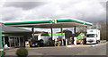
White Post garage on the A30
West of Yeovil
Image: © John Firth
Taken: 12 Apr 2013
0.10 miles
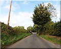
5
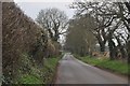
South Somerset : Camp Road
Camp Road heading towards Odcombe in South Somerset.
Image: © Lewis Clarke
Taken: 16 Mar 2012
0.14 miles
6

South Somerset : Feebarrow House
Feebarrow House on Camp Road near West Coker.
Image: © Lewis Clarke
Taken: 16 Mar 2012
0.14 miles
7

Green lane and footpath near Holywell
Just as one enters the holloway from Holywell to the A37 there is a green lane on the left which continues up to the main road and over to Feebarrow.
Image: © Sarah Smith
Taken: 2 Apr 2009
0.16 miles
8
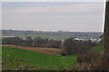
South Somerset : Grassy Field & Yeovil View
Looking down towards the grassy field with parts of Yeovil in the distance.
Image: © Lewis Clarke
Taken: 16 Mar 2012
0.16 miles
9

South Somerset : Grassy Field & Yeovil Panorama
Looking back down towards Yeovil where the aerodrome and other buildings can be picked out. To have a closer look, view the buttom to see more sizes.
Image: © Lewis Clarke
Taken: 16 Mar 2012
0.18 miles
10
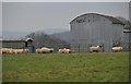
South Somerset : Sheep Grazing
Sheep grazing in a grassy field off of Camp Road.
Image: © Lewis Clarke
Taken: 16 Mar 2012
0.18 miles