1
White Post garage on the A30
West of Yeovil
Image: © John Firth
Taken: 12 Apr 2013
0.02 miles
2
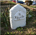
Old Milestone by the A30, West Coker Road, Yeovil
Metal plate attached to stone post by the A30, in parish of YEOVIL (SOUTH SOMERSET District), West Coker Road, West side of petrol station, 80m South West of junction with Camp Road, on the verge, on North side of road. Yeovil roll top iron plate, erected by the Yeovil turnpike trust in the 18th century.
Inscription reads:-
II
YEOVIL
Grade II listed.
List Entry Number: 1417781 https://historicengland.org.uk/listing/the-list/list-entry/1417781
Milestone Society National ID: SO_YVCW02.
Image: © Alan Rosevear
Taken: 27 Apr 2011
0.03 miles
3
BP filling station, Inglemount, west of Yeovil on A30
Image: © David Smith
Taken: 5 Jun 2014
0.03 miles
4
Approaching junction with the A30
Image: © Roger Cornfoot
Taken: 19 Sep 2018
0.06 miles
5
South Somerset : Grassy Field & Yeovil View
Looking down towards the grassy field with parts of Yeovil in the distance.
Image: © Lewis Clarke
Taken: 16 Mar 2012
0.07 miles
6
South Somerset : Grassy Field & Yeovil Panorama
Looking back down towards Yeovil where the aerodrome and other buildings can be picked out. To have a closer look, view the buttom to see more sizes.
Image: © Lewis Clarke
Taken: 16 Mar 2012
0.08 miles
7
South Somerset : Yeovil Panoramic View
Looking down towards Yeovil with Preston Plucknett and Houndstone in view.
Image: © Lewis Clarke
Taken: 16 Mar 2012
0.11 miles
8
South Somerset : A30 West Coker Road & Yeovil Sign
A sign telling people they're entering Yeovil on the A30.
Image: © Lewis Clarke
Taken: 16 Mar 2012
0.12 miles
9
South Somerset : Camp Road
Camp Road heading towards Odcombe in South Somerset.
Image: © Lewis Clarke
Taken: 16 Mar 2012
0.13 miles
10
A30 into Yeovil
Approaching Yeovil there are the turnings to Odcombe and Stoke sub Hamdon on the left and East Coker and Hardington Mandeville on the right.
Image: © Sarah Smith
Taken: 31 May 2009
0.14 miles


