IMAGES TAKEN NEAR TO
Hornbeam Vale, BA22 8ZE
Introduction
This page details the photographs taken nearby to Hornbeam Vale, BA22 8ZE by members of the Geograph project.
The Geograph project started in 2005 with the aim of publishing, organising and preserving representative images for every square kilometre of Great Britain, Ireland and the Isle of Man.

There are currently over 7.5m images from over14,400 individuals and you can help contribute to the project by visiting https://www.geograph.org.uk
Image Map
Images are licensed for reuse under creativecommons.org/licenses/by-sa/2.0
Notes
- Clicking on the map will re-center to the selected point.
- The higher the marker number, the further away the image location is from the centre of the postcode.
Image Listing (11 Images Found)
Images are licensed for reuse under creativecommons.org/licenses/by-sa/2.0
Image
Details
Distance
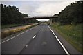
4
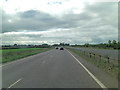
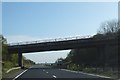
A303 Looking East
From the bridge to the north of Illchester.
Image: © Steve Barnes
Taken: 10 Aug 2011
0.21 miles
5
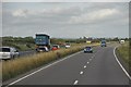
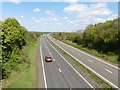
South Somerset : The A303
The A303 heading through South Somerset.
Image: © Lewis Clarke
Taken: 28 Aug 2012
0.21 miles
6
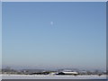
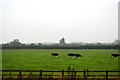
An Ilchester Farm
A farm and surrounding land on the edge of the A303.
Image: © Jason Roffey
Taken: 18 Dec 2010
0.21 miles

10
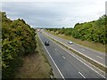
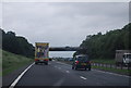
South Somerset : The A303
The A303 in South Somerset near Ilchester.
Image: © Lewis Clarke
Taken: 23 Aug 2012
0.23 miles