IMAGES TAKEN NEAR TO
Higher Odcombe, YEOVIL, BA22 8XB
Introduction
This page details the photographs taken nearby to BA22 8XB by members of the Geograph project.
The Geograph project started in 2005 with the aim of publishing, organising and preserving representative images for every square kilometre of Great Britain, Ireland and the Isle of Man.

There are currently over 7.5m images from over14,400 individuals and you can help contribute to the project by visiting https://www.geograph.org.uk
Image Map
Images are licensed for reuse under creativecommons.org/licenses/by-sa/2.0
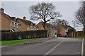
Notes
- Clicking on the map will re-center to the selected point.
- The higher the marker number, the further away the image location is from the centre of the postcode.
Image Listing (45 Images Found)
Images are licensed for reuse under creativecommons.org/licenses/by-sa/2.0
Image
Details
Distance
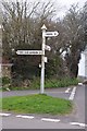
2
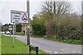
Old Direction Sign - Signpost by Old Road, Odcombe parish
Pyramid finial - 4 arms; Somerset pointing fingers by the UC road, in parish of Odcombe (South Somerset District), Camp Road and Old Road crossroads, on grass island.
Surveyed
Milestone Society National ID: SO_ST5015
Image: © Milestone Society
Taken: Unknown
0.02 miles
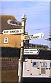
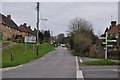
3
Odcombe : Ham Hill Road Signpost
A signpost seen with directions to nearby settlements on Ham Hill Road.
Image: © Lewis Clarke
Taken: 16 Mar 2012
0.03 miles
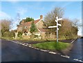
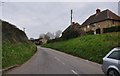
4
Odcombe : Ham Hill Road
A road in Odcombe which is also part of a speed control area.
Image: © Lewis Clarke
Taken: 16 Mar 2012
0.03 miles
5
Odcombe : Ham Hill Road
Ham Hill Road in Odcombe which in this direction heads towards Ham Hill Country Park.
Image: © Lewis Clarke
Taken: 16 Mar 2012
0.03 miles
6
Odcombe : Road to East Chinnock
A road to East Chinnock from Odcombe.
Image: © Lewis Clarke
Taken: 16 Mar 2012
0.05 miles
7
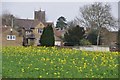
Odcombe : Oilseed Rape & Odcombe View
Looking back towards the village of Odcombe from Camp Road.
Image: © Lewis Clarke
Taken: 16 Mar 2012
0.07 miles
8
Odcombe : Long Run
A road known as Long Run in Odcombe - it provides access to the houses which can be seen.
Image: © Lewis Clarke
Taken: 16 Mar 2012
0.08 miles
9
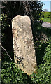
Old Milestone by Camp Road, Odcombe parish
Carved stone post by the UC road, in parish of ODCOMBE (SOUTH SOMERSET District), Camp Road, near junction with Old Road, at entrance to village, beside village sign and footpath, on South side of road. Erected by the Yeovil turnpike trust in the 18th century.
Inscription is almost illegible and reads:-
MILES
(??)
Grade II listed.
List Entry Number: 1260554 https://historicengland.org.uk/listing/the-list/list-entry/1260554
Milestone Society National ID: SO_LEY126.
Image: © A Rosevear
Taken: 12 Apr 2011
0.11 miles