
IMAGES TAKEN NEAR TO
Head Street, YEOVIL, BA22 8QQ
Introduction
This page details the photographs taken nearby to Head Street, BA22 8QQ by members of the Geograph project.
The Geograph project started in 2005 with the aim of publishing, organising and preserving representative images for every square kilometre of Great Britain, Ireland and the Isle of Man.

There are currently over 7.5m images from over14,400 individuals and you can help contribute to the project by visiting https://www.geograph.org.uk
Image Map
Images are licensed for reuse under creativecommons.org/licenses/by-sa/2.0
Notes
- Clicking on the map will re-center to the selected point.
- The higher the marker number, the further away the image location is from the centre of the postcode.
Image Listing (37 Images Found)
Images are licensed for reuse under creativecommons.org/licenses/by-sa/2.0
Image
Details
Distance
1
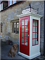
K1 telephone kiosk
K1 telephone kiosk outside the Old Post Office in Head Street,Tintinhull, Somerset.
Image: © Melanie Josling
Taken: 26 Feb 2010
0.04 miles

3

Old Direction Sign - Signpost by Head Street, Tintinhull
Pyramid finial - 3 arms; Somerset SCC pyramid by the UC road, in parish of Tintinhull (South Somerset District), Head Street junction with Montacute Road, by bus shelter.
Surveyed
Milestone Society National ID: SO_ST4919
Image: © Alan Rosevear
Taken: 12 Apr 2011
0.05 miles
4
![Tintinhull houses [6]](https://s1.geograph.org.uk/geophotos/07/53/41/7534169_a431f748_120x120.jpg)
Tintinhull houses [6]
Batcombe House, 15 Head Street, was built in the 17th century with later alterations and additions. Constructed of squared Ham stone with ashlar dressings under a pantile roof. There are lean-to additions buildings against both end gables. Listed, grade II, with details at: https://historicengland.org.uk/listing/the-list/list-entry/1235191
This image also shows, in context, the boundary or direction stone seen closer at Image Listed, grade II, with details at: https://historicengland.org.uk/listing/the-list/list-entry/1235192
Tintinhull is a village in Somerset, some 4¼ miles northwest of Yeovil and about 17¼ miles southeast of Taunton. Originally an agricultural village with the surrounding landscape containing evidence of 2,000 years of farming, however, most working residents now commute. Mentioned in the Domesday Book, the village is home to the 17th century Tintinhull House and Gardens.
Image: © Michael Dibb
Taken: 19 May 2023
0.10 miles
5

Old Milestone(?), Head Street, Tintinhull
Carved stone post by the UC road, in parish of TINTINHULL (SOUTH SOMERSET District), Head Street, junction with St Margaret's Road, on the verge by valve marker posts, on South side of road. Yeovil gabled iron plate erected by the Yeovil turnpike trust in the 18th century.
For view of front of stone see https://www.flickr.com/photos/tollhouses/5616301686
No discernable inscription.
Grade II listed.
List Entry Number: 1235192 https://historicengland.org.uk/listing/the-list/list-entry/1235192
Listing describes it as Boundary or Direction stone.
Milestone Society National ID: SO_YVTH04a
Image: © A Rosevear
Taken: 12 Apr 2011
0.10 miles
6
![Tintinhull features [3]](https://s0.geograph.org.uk/geophotos/07/53/41/7534172_a55659d4_120x120.jpg)
Tintinhull features [3]
This large stone in Head Street is possibly a direction stone on this un-turnpiked road, being at a significant road junction in the village. Ham stone, about 4 feet high, of uncertain date. No inscription is visible, but with indication of former lettering. The stone is seen in context at Image Listed, grade II, with details at: https://historicengland.org.uk/listing/the-list/list-entry/1235192
Tintinhull is a village in Somerset, some 4¼ miles northwest of Yeovil and about 17¼ miles southeast of Taunton. Originally an agricultural village with the surrounding landscape containing evidence of 2,000 years of farming, however, most working residents now commute. Mentioned in the Domesday Book, the village is home to the 17th century Tintinhull House and Gardens.
Image: © Michael Dibb
Taken: 19 May 2023
0.10 miles
7
![Tintinhull houses [5]](https://s3.geograph.org.uk/geophotos/07/53/41/7534167_957e3183_120x120.jpg)
Tintinhull houses [5]
Court Dairy House, 24 St Margaret's Road, was built in the 17th century with a bay added in the 18th century. Constructed of squared Ham stone with some coursed rubble stone under a thatch roof. There is a single storey extension at the rear with a hipped double Roman tile roof. Listed, grade II, with details at: https://historicengland.org.uk/listing/the-list/list-entry/1265051
Tintinhull is a village in Somerset, some 4¼ miles northwest of Yeovil and about 17¼ miles southeast of Taunton. Originally an agricultural village with the surrounding landscape containing evidence of 2,000 years of farming, however, most working residents now commute. Mentioned in the Domesday Book, the village is home to the 17th century Tintinhull House and Gardens.
Image: © Michael Dibb
Taken: 19 May 2023
0.12 miles
8
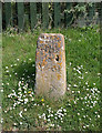
Old Milestone by Montacute Road, Tintinhull
Carved stone post by the UC road, in parish of TINTINHULL (SOUTH SOMERSET District), Montacute Road, on bend at South side of village, on grass verge, on East side of road. Erected by the Yeovil turnpike trust in the 18th century.
Inscription reads:-
(5)
Miles
To
Yeovil
Grade II Listed. List Entry Number: 1235214
https://historicengland.org.uk/listing/the-list/list-entry/1235214
Milestone Society National ID: SO_YVTH05a.
Image: © Alan Rosevear
Taken: 12 Apr 2011
0.16 miles
9
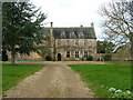
Tintinhull Court House, Somerset
Tintinhull is pronounced locally (as approximately!) Tink'nel.
Image: © Dave Napier
Taken: 14 Feb 2005
0.17 miles
10
![Tintinhull features [4]](https://s1.geograph.org.uk/geophotos/07/53/41/7534177_b8e5844b_120x120.jpg)
Tintinhull features [4]
This fine, hard-working gentleman stands outside number 1 Head Street.
Tintinhull is a village in Somerset, some 4¼ miles northwest of Yeovil and about 17¼ miles southeast of Taunton. Originally an agricultural village with the surrounding landscape containing evidence of 2,000 years of farming, however, most working residents now commute. Mentioned in the Domesday Book, the village is home to the 17th century Tintinhull House and Gardens.
Image: © Michael Dibb
Taken: 19 May 2023
0.19 miles