
IMAGES TAKEN NEAR TO
Abbots Road, YEOVIL, BA22 8NA
Introduction
This page details the photographs taken nearby to Abbots Road, BA22 8NA by members of the Geograph project.
The Geograph project started in 2005 with the aim of publishing, organising and preserving representative images for every square kilometre of Great Britain, Ireland and the Isle of Man.

There are currently over 7.5m images from over14,400 individuals and you can help contribute to the project by visiting https://www.geograph.org.uk
Image Map
Images are licensed for reuse under creativecommons.org/licenses/by-sa/2.0
Notes
- Clicking on the map will re-center to the selected point.
- The higher the marker number, the further away the image location is from the centre of the postcode.
Image Listing (176 Images Found)
Images are licensed for reuse under creativecommons.org/licenses/by-sa/2.0
Image
Details
Distance
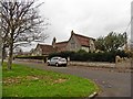
2
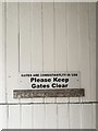
Sign, Ilchester
Sign on a gate that is consistantlty (sic) in use, High Street, Ilchester.
Image: © Rossographer
Taken: 9 Aug 2019
0.10 miles
3
![Ilchester houses [18]](https://s0.geograph.org.uk/geophotos/07/51/22/7512244_a8120bd3_120x120.jpg)
Ilchester houses [18]
Number 4 West Street is a cottage in a terrace built along this side of the road in or soon after 1820, and probably of the last group to be built. Constructed of brick under a tile roof, The upper windows are horizontal sliding sashes. Listed, grade II, with details at: https://historicengland.org.uk/listing/the-list/list-entry/1223195
Ilchester is a village in Somerset, situated astride the River Yeo or Ivel, some 4½ miles northwest of Yeovil and about 18 miles east of Taunton. Originally an important Roman town, Lindinis, on the Fosse Way and later a market town, in the medieval period Ilchester was the county town. It declined in size and importance and the last markets were held in 1833. The name was recorded in the Domesday Book as Givelcestre, meaning "Roman fort on the River Yeo".
Image: © Michael Dibb
Taken: 18 May 2023
0.10 miles
4
![Ilchester houses [15]](https://s3.geograph.org.uk/geophotos/07/51/22/7512235_b83bcb14_120x120.jpg)
Ilchester houses [15]
Number 21 High Street, nearer the camera, and number 22 High Street are two little-altered cottages in a terrace built in or soon after 1820. Constructed of brick under tile roofs. Listed, grade II, with details at: https://historicengland.org.uk/listing/the-list/list-entry/1267505 (number 21) and at: https://historicengland.org.uk/listing/the-list/list-entry/1057299 (number 22).
Ilchester is a village in Somerset, situated astride the River Yeo or Ivel, some 4½ miles northwest of Yeovil and about 18 miles east of Taunton. Originally an important Roman town, Lindinis, on the Fosse Way and later a market town, in the medieval period Ilchester was the county town. It declined in size and importance and the last markets were held in 1833. The name was recorded in the Domesday Book as Givelcestre, meaning "Roman fort on the River Yeo".
Image: © Michael Dibb
Taken: 18 May 2023
0.10 miles
5
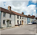
Colour-washed cottages, High Street, Ilchester
No. 21 (to the left) from the early 19th Century is Grade-II listed: http://www.britishlistedbuildings.co.uk/en-263443-21-high-street-ilchester-somerset#.V5UN0CZTGmQ .
Image: © Bill Harrison
Taken: 3 Jul 2016
0.11 miles
6

Pedestrian overbridge on the A37, near Ilchester
Image: © Roger Cornfoot
Taken: 19 Apr 2017
0.11 miles
7
![Ilchester houses [17]](https://s0.geograph.org.uk/geophotos/07/51/22/7512240_61e70b0f_120x120.jpg)
Ilchester houses [17]
Number 2 Manor House, West Street, and number 3 Manor House, West Street (nearer the camera) were both formerly parts of the service wing of the Manor House (see number 1 Manor House Image).
Number 2 Manor House was built in the 19th century of squared lias stone with Ham stone dressings under a Welsh slate roof. The entrance is to the rear. Listed, grade II, with details at: https://historicengland.org.uk/listing/the-list/list-entry/1223193
Number 3 Manor House was built in the 19th century with a 20th century extension. Constructed of squared lias stone with Ham stone dressings with a Welsh slate roof to the main block and a Bridgwater interlocking tile roof to the extension. Listed, grade II, with details at: https://historicengland.org.uk/listing/the-list/list-entry/1223194
Ilchester is a village in Somerset, situated astride the River Yeo or Ivel, some 4½ miles northwest of Yeovil and about 18 miles east of Taunton. Originally an important Roman town, Lindinis, on the Fosse Way and later a market town, in the medieval period Ilchester was the county town. It declined in size and importance and the last markets were held in 1833. The name was recorded in the Domesday Book as Givelcestre, meaning "Roman fort on the River Yeo".
with north abutment and south continuation. Two storeys, single bay street elevation: high plinth, mullioned windows of 3 lights without labels; small C20 window added to right. Entrance off yard to rear of The Manor House, east elevation 2 bays, rendered; bay 1 has 3-light mullioned windows, and upper bay 2 a 2-light to match; part glazed door to lower bay 2, with added small casement windows between bays. Interior not seen.
Image: © Michael Dibb
Taken: 18 May 2023
0.11 miles
8
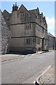
Ilchester: Manor House
At the corner of West Street and Almshouse Lane. Dating from the mid seventeenth century it was considerably altered in the eighteenth. This was at one time the home of the Tory, Sir William Manners, Lord Huntingtowers, who bought the manor of Ilchester from the town corporation in 1808, for political gain. It ishard to appreciate now, but until 1846 Ilchester was the county town of Somerset and returned two MPs to parliament. It remained one of the 'rotten boroughs' along with Old Sarum, Calne and others until the Reform Act of 1832. By the road that was originally the Roman Fosse Way
Image: © Martin Bodman
Taken: 30 Jun 2012
0.11 miles
9
![Ilchester houses [16]](https://s0.geograph.org.uk/geophotos/07/51/22/7512236_1674cf27_120x120.jpg)
Ilchester houses [16]
Number 1 Manor House, West Street, is part of a large corner house, built in the 17th century, much altered and greatly restored in the late 20th century. Constructed of rendered stone with Ham and artificial stone dressings under a concrete tile roof. Inside, the northwest corner room on the ground floor has Jacobean oak panelling with Corinthian pilasters. Other ground floor rooms are panelled. The house was never an actual manor house, has endured drastic external restoration and has been subdivided. Listed, grade II, with details at: https://historicengland.org.uk/listing/the-list/list-entry/1223506
Ilchester is a village in Somerset, situated astride the River Yeo or Ivel, some 4½ miles northwest of Yeovil and about 18 miles east of Taunton. Originally an important Roman town, Lindinis, on the Fosse Way and later a market town, in the medieval period Ilchester was the county town. It declined in size and importance and the last markets were held in 1833. The name was recorded in the Domesday Book as Givelcestre, meaning "Roman fort on the River Yeo".
Image: © Michael Dibb
Taken: 18 May 2023
0.11 miles
10
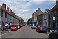
Ilchester: High Street
Looking north-north-east towards the Market Square. This was originally the Roman Fosse Way. With the village - or is it town - pharmacy on the right and the Dolphin inn beyond
Image: © Martin Bodman
Taken: 30 Jun 2012
0.11 miles