IMAGES TAKEN NEAR TO
Sparkford Road, YEOVIL, BA22 7PF
Introduction
This page details the photographs taken nearby to Sparkford Road, BA22 7PF by members of the Geograph project.
The Geograph project started in 2005 with the aim of publishing, organising and preserving representative images for every square kilometre of Great Britain, Ireland and the Isle of Man.

There are currently over 7.5m images from over14,400 individuals and you can help contribute to the project by visiting https://www.geograph.org.uk
Image Map
Images are licensed for reuse under creativecommons.org/licenses/by-sa/2.0
Notes
- Clicking on the map will re-center to the selected point.
- The higher the marker number, the further away the image location is from the centre of the postcode.
Image Listing (76 Images Found)
Images are licensed for reuse under creativecommons.org/licenses/by-sa/2.0
Image
Details
Distance
1
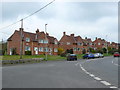
Houses on Sparkford Hill
These ex-council houses are on the A359 Yeovil to Sparkford road just north of Camel bridge where the road crosses the River Cam. The road now intersects with the A303 at the Sparkford roundabout.
Image: © Nigel Mykura
Taken: 14 Apr 2012
0.05 miles
2
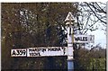
Direction Sign - Signpost on the A359 at Queen Camel
Pyramid finial - 3 arms; Somerset SCC pyramid by the A359, in parish of Queen Camel (South Somerset District), on the Southwest side of the junction of the A359 and Blackwell Road.
Surveyed
Milestone Society National ID: SO_ST5925
Image: © Milestone Society
Taken: Unknown
0.11 miles

4
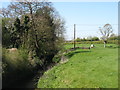
The River Cam at Queen Camel
To the best of my knowledge, there are three rivers called "River Cam" in Britain. As a graduate (and Fellow Commoner) of Sidney Sussex College, Cambridge, I am familiar with the best-known River Cam.
The second one is in Gloucestershire, flowing through Dursley and another Cambridge (this one a small village in Image) on its way to the River Severn.
Finally we have the Somerset River Cam, almost certainly the least known of the three. This flows through Sparkford and Queen Camel before joining the River Yeo (Ivel). It is seen here in Queen Camel, looking downstream.
Image: © David Purchase
Taken: 21 Apr 2015
0.13 miles
5

Picked plums for passers-by
A small crowd of characters rest awhile, whilst some fresh produce is offered.
Image: © Neil Owen
Taken: 19 Aug 2022
0.13 miles
6
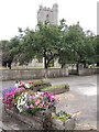
Floral display in front of St Barnabas
A small triangle between the roads is used to give a bright welcome visitors to the village.
Image: © Neil Owen
Taken: 19 Aug 2022
0.13 miles
7
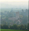
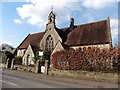
Schoolhouse and Church in the morning mist, Queen Camel, Somerset
In the late morning mist, a shot from the hillside above Queen Camel, including the 1872 schoolhouse and 14th century Church of St Barnabas, with the fields and hills of Blackmore Vale stretching into the mist behind.
This site, according to the Tudor antiquarian John Leland, was the site of King Arthur’s last stand.
Image: © Edmund Shaw
Taken: 28 Sep 2013
0.14 miles

9

Cottages on Grace Martin's Lane
A beautifully thatched row of cottages opposite the church. The middle one is actually Grade II listed, although most are not.
Image: © Neil Owen
Taken: 19 Aug 2022
0.15 miles