IMAGES TAKEN NEAR TO
Wales, YEOVIL, BA22 7PD
Introduction
This page details the photographs taken nearby to Wales, BA22 7PD by members of the Geograph project.
The Geograph project started in 2005 with the aim of publishing, organising and preserving representative images for every square kilometre of Great Britain, Ireland and the Isle of Man.

There are currently over 7.5m images from over14,400 individuals and you can help contribute to the project by visiting https://www.geograph.org.uk
Image Map
Images are licensed for reuse under creativecommons.org/licenses/by-sa/2.0
Notes
- Clicking on the map will re-center to the selected point.
- The higher the marker number, the further away the image location is from the centre of the postcode.
Image Listing (5 Images Found)
Images are licensed for reuse under creativecommons.org/licenses/by-sa/2.0
Image
Details
Distance
1
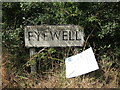
Eyewell sign
A small hamlet near Queen Camel is approached along Blackwell Lane. Of late, the local authorities are about to expand the main A303 in the area and are looking to use their powers as the work permeates the rural landscape.
Image: © Neil Owen
Taken: 19 Aug 2022
0.04 miles
2
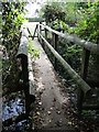
Crossing the Cam near Wales
The River Cam in Somerset, note! Wales is actually a small hamlet and farmstead close by.
Image: © Neil Owen
Taken: 19 Aug 2022
0.09 miles
3
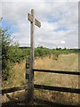
On the Leland Trail
A footpath to the north of Queen Camel is a long distance path. John Leland was an antiquary commissioned by Henry VIII to record the various treasures in Somerset; the modern path starts at King Alfred's Tower, Penselwood, and reaches as far as Ham Hill Country Park near Yeovil.
Image: © Neil Owen
Taken: 19 Aug 2022
0.10 miles
4

Green Lane Sewage Pumping Station
A small facility in a quiet spot in the field. No-one works here as the station is automatic.
Image: © Neil Owen
Taken: 19 Aug 2022
0.20 miles
5

Leland Trail near Queen Camel
Following the trail westwards through meadows towards West Camel
Image: © Chris Heaton
Taken: 19 May 2002
0.21 miles