IMAGES TAKEN NEAR TO
Sparkford, YEOVIL, BA22 7LD
Introduction
This page details the photographs taken nearby to BA22 7LD by members of the Geograph project.
The Geograph project started in 2005 with the aim of publishing, organising and preserving representative images for every square kilometre of Great Britain, Ireland and the Isle of Man.

There are currently over 7.5m images from over14,400 individuals and you can help contribute to the project by visiting https://www.geograph.org.uk
Image Map
Images are licensed for reuse under creativecommons.org/licenses/by-sa/2.0
Notes
- Clicking on the map will re-center to the selected point.
- The higher the marker number, the further away the image location is from the centre of the postcode.
Image Listing (16 Images Found)
Images are licensed for reuse under creativecommons.org/licenses/by-sa/2.0
Image
Details
Distance
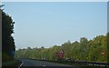
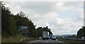
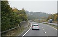
1
A303 heading west
Looping around Sparkford.
Image: © Robin Webster
Taken: 7 Sep 2019
0.10 miles
2
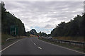
A303 approaching A359 junction
Turn off for Bruton and Frome.
Image: © Julian P Guffogg
Taken: 12 Aug 2013
0.11 miles
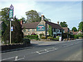
3
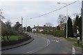
High Street, Sparkford
This used to be the A303 until the bypass was built. Still an A road, but a lot quieter.
Image: © Richard Webb
Taken: 7 Apr 2015
0.18 miles
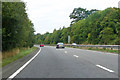
4
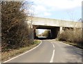
Concrete road bridge carrying the A303
Image: © Roger Cornfoot
Taken: 28 Feb 2018
0.18 miles
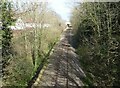
8
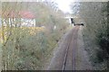
Wilts, Somerset and Weymouth Railway
The railway from Westbury to Weymouth via Yeovil passes through Sparkford.
Image: © Richard Webb
Taken: 7 Apr 2015
0.18 miles