IMAGES TAKEN NEAR TO
North Cadbury, YEOVIL, BA22 7BZ
Introduction
This page details the photographs taken nearby to BA22 7BZ by members of the Geograph project.
The Geograph project started in 2005 with the aim of publishing, organising and preserving representative images for every square kilometre of Great Britain, Ireland and the Isle of Man.

There are currently over 7.5m images from over14,400 individuals and you can help contribute to the project by visiting https://www.geograph.org.uk
Image Map
Images are licensed for reuse under creativecommons.org/licenses/by-sa/2.0
Notes
- Clicking on the map will re-center to the selected point.
- The higher the marker number, the further away the image location is from the centre of the postcode.
Image Listing (6 Images Found)
Images are licensed for reuse under creativecommons.org/licenses/by-sa/2.0
Image
Details
Distance
3
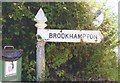
Old Direction Sign - Signpost by Cary Road, North Cadbury Parish
Pyramid finial - 1 arm; Somerset SCC pyramid by the UC road, in parish of North Cadbury (South Somerset District), Cary Road junction with lane to Brookhampton.
Surveyed
Milestone Society National ID: SO_ST6327B
Image: © Milestone Society
Taken: Unknown
0.23 miles
4
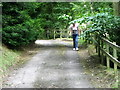
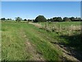
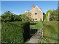
Footpath, North Cadbury
The footpath takes walkers down the drive to Brookhampton House.
Image: © Maigheach-gheal
Taken: 1 Aug 2010
0.23 miles
6
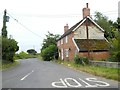
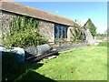
Cary Road and roadside cottage
Built of brick with an end wall of stone
Image: © David Smith
Taken: 9 Jul 2019
0.24 miles