IMAGES TAKEN NEAR TO
North Cadbury, YEOVIL, BA22 7BD
Introduction
This page details the photographs taken nearby to BA22 7BD by members of the Geograph project.
The Geograph project started in 2005 with the aim of publishing, organising and preserving representative images for every square kilometre of Great Britain, Ireland and the Isle of Man.

There are currently over 7.5m images from over14,400 individuals and you can help contribute to the project by visiting https://www.geograph.org.uk
Image Map
Images are licensed for reuse under creativecommons.org/licenses/by-sa/2.0
Notes
- Clicking on the map will re-center to the selected point.
- The higher the marker number, the further away the image location is from the centre of the postcode.
Image Listing (10 Images Found)
Images are licensed for reuse under creativecommons.org/licenses/by-sa/2.0
Image
Details
Distance
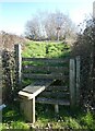
2
Dilapidated public footbridge on North Leaze Farm
Image: © Roger Cornfoot
Taken: 7 Mar 2022
0.14 miles
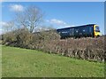
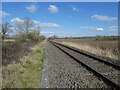
9
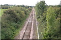
Single track
Single track railway line heading South West towards Sparkford
Image: © Shaun Ferguson
Taken: 19 Sep 2007
0.24 miles