IMAGES TAKEN NEAR TO
Galhampton Road, YEOVIL, BA22 7AA
Introduction
This page details the photographs taken nearby to Galhampton Road, BA22 7AA by members of the Geograph project.
The Geograph project started in 2005 with the aim of publishing, organising and preserving representative images for every square kilometre of Great Britain, Ireland and the Isle of Man.

There are currently over 7.5m images from over14,400 individuals and you can help contribute to the project by visiting https://www.geograph.org.uk
Image Map
Images are licensed for reuse under creativecommons.org/licenses/by-sa/2.0
Notes
- Clicking on the map will re-center to the selected point.
- The higher the marker number, the further away the image location is from the centre of the postcode.
Image Listing (9 Images Found)
Images are licensed for reuse under creativecommons.org/licenses/by-sa/2.0
Image
Details
Distance
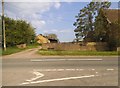
2
Road junction of A359 with B3152 at Redlands Farm
Image: © David Smith
Taken: 9 Jul 2019
0.02 miles
3
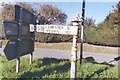
Direction Sign - Signpost on the junction of the A369 and the B3152
Pyramid finial - 1 arm; Somerset SCC pyramid by the A359, in parish of Castle Cary (South Somerset District), on the southwest side of the Y-junction of the A359 Galhampton Hill and the B3162 by old tollhouse SO.CAS. Image
Surveyed
Milestone Society National ID: SO_ST6330
Image: © Milestone Society
Taken: Unknown
0.03 miles
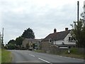
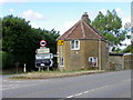
4

Old Toll House, Galhampton
Toll House on High Road (A359) at the junction with Galhampton Hill, BA7 7PF.
The signpost on the left is: SO_ST6330 Image
Somerset HER.
HER number: 40732 https://www.heritagegateway.org.uk/Gateway/Results_Single.aspx?uid=40732&resourceID=100
Surveyed
Milestone Society National ID: SO.CAS
Image: © Alan Rosevear
Taken: 3 Sep 2009
0.03 miles

6
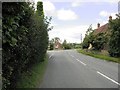
The A359 approaching the junction with the B3152
Image: © David Gearing
Taken: 6 Aug 2011
0.04 miles
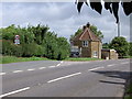
7
Tollhouse near Galhampton
The tollhouse stands on the junction of the B3152 and the A357. The roads formed part of the turnpike controlled by the Langport, Somerton and Castle Cary Turnpike Trust. This trust was created in 1753 as a multi-centred trust. Its main responsibilities were the east/west road on the high ground above the Somerset Levels and a network of minor roads into the three market towns of mid Somerset.
The tollhouse was known as the Galhampton Hill Gate but many of the trusts records are a bit vague and the gate may have been called the Shepherd's Hill Gate.
Turnpikes were administered by turnpike trusts, which were authorised by private act of parliament. The trusts laid down a network of soundly constructed roads throughout the country, replacing parochial maintenance system on many highways and substantially improving communications. The first English turnpike roads were authorised by an act of 1663. By the 1800s there were about 8000 tollgates and 22,000 miles of highway. The trusts engineers, notably John Macadam, constructed many new roads, which by the 1800s were being utilized by an efficient stagecoach system. However, railway expansion after 1830 led to the rapid decline of stagecoaches and turnpike revenue.
Image: © Maigheach-gheal
Taken: 1 Aug 2010
0.04 miles
8
Former turnpike cottage
At junction of B3152 and A359 at Galhampton, near Castle Cary
Image: © J Tucker
Taken: 20 Jun 2007
0.08 miles
