IMAGES TAKEN NEAR TO
Sherwell Close, YEOVIL, BA21 5EE
Introduction
This page details the photographs taken nearby to Sherwell Close, BA21 5EE by members of the Geograph project.
The Geograph project started in 2005 with the aim of publishing, organising and preserving representative images for every square kilometre of Great Britain, Ireland and the Isle of Man.

There are currently over 7.5m images from over14,400 individuals and you can help contribute to the project by visiting https://www.geograph.org.uk
Image Map (Loading...)


Getting Data...Please wait
Leaflet Map data © OpenStreetMap
Images are licensed for reuse under creativecommons.org/licenses/by-sa/2.0
Notes
- Clicking on the map will re-center to the selected point.
- The higher the marker number, the further away the image location is from the centre of the postcode.
Image Listing (6 Images Found)
Images are licensed for reuse under creativecommons.org/licenses/by-sa/2.0
Image
Details
Distance
1
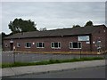
Birchfield Community Centre
Next door to the primary school.
Image: © Steve Barnes
Taken: 17 Aug 2009
0.08 miles
2
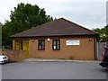
Birchfield County Primary School
This photo shows the school with some work on the roof underway during the summer holidays.
Image: © Steve Barnes
Taken: 17 Aug 2009
0.11 miles
3
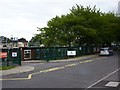
Oaklands Surgery
This doctors' surgery is close to the Burchfield Primary and Bucklers Mead Schools.
Image: © Steve Barnes
Taken: 17 Aug 2009
0.12 miles
4

Benchmark on 201 St Michael's Avenue, Yeovil
Ordnance Survey benchmark, described on database at http://www.bench-marks.org.uk/bm68520.
Image: © Becky Williamson
Taken: 29 Jun 2015
0.15 miles
5
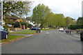
St Michael's Avenue, Yeovil
A residential road with speed bumps.
Image: © Robin Webster
Taken: 3 Nov 2018
0.15 miles
6
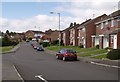
Runnymede Road, Yeovil
A road through an estate in the north-eastern part of Yeovil's suburbs. At the end can be seen a small parade of shops; the red lorry is delivering to a supermarket.
Image: © Derek Harper
Taken: 30 Aug 2007
0.23 miles