IMAGES TAKEN NEAR TO
St. Georges Avenue, YEOVIL, BA21 4QY
Introduction
This page details the photographs taken nearby to St. Georges Avenue, BA21 4QY by members of the Geograph project.
The Geograph project started in 2005 with the aim of publishing, organising and preserving representative images for every square kilometre of Great Britain, Ireland and the Isle of Man.

There are currently over 7.5m images from over14,400 individuals and you can help contribute to the project by visiting https://www.geograph.org.uk
Image Map (Loading...)


Getting Data...Please wait
Leaflet Map data © OpenStreetMap
Images are licensed for reuse under creativecommons.org/licenses/by-sa/2.0
Notes
- Clicking on the map will re-center to the selected point.
- The higher the marker number, the further away the image location is from the centre of the postcode.
Image Listing (13 Images Found)
Images are licensed for reuse under creativecommons.org/licenses/by-sa/2.0
Image
Details
Distance
1
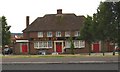
Yeovil: House renovations in St George's Avenue
Image: © Mr Eugene Birchall
Taken: 24 Jan 2011
0.08 miles
2

Millford Dip Allotments
These are now the only remaining allotments on Milford Road
Image: © Steve Barnes
Taken: 19 Jul 2009
0.14 miles
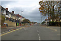
3

Looking down Goldcroft from entrance to College Green estate
Image: © Michael W Beales BEM
Taken: 7 Dec 2010
0.14 miles


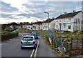
6
Glenthorne Avenue, Yeovil
A residential road with frequent chicanes and speed bumps.
Image: © Robin Webster
Taken: 3 Nov 2018
0.19 miles
7

Millford Dip
This stage of Millford Road is, for obvious reasons, known locally as Millford Dip.
Image: © Steve Barnes
Taken: 19 Jul 2009
0.20 miles

9
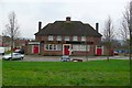
The Milford Inn
This pub is close to the centre of one of the main council estates on the eastern side of Yeovil
Image: © Nigel Mykura
Taken: 31 Jan 2009
0.21 miles