IMAGES TAKEN NEAR TO
St. Johns Road, YEOVIL, BA21 4NH
Introduction
This page details the photographs taken nearby to St. Johns Road, BA21 4NH by members of the Geograph project.
The Geograph project started in 2005 with the aim of publishing, organising and preserving representative images for every square kilometre of Great Britain, Ireland and the Isle of Man.

There are currently over 7.5m images from over14,400 individuals and you can help contribute to the project by visiting https://www.geograph.org.uk
Image Map (Loading...)


Getting Data...Please wait
Leaflet Map data © OpenStreetMap
Images are licensed for reuse under creativecommons.org/licenses/by-sa/2.0
Notes
- Clicking on the map will re-center to the selected point.
- The higher the marker number, the further away the image location is from the centre of the postcode.
Image Listing (5 Images Found)
Images are licensed for reuse under creativecommons.org/licenses/by-sa/2.0
Image
Details
Distance
2
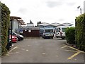
Entrance, Fairmead Community Special School
Image: © Roger Cornfoot
Taken: 18 Jul 2018
0.12 miles
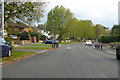
4

Benchmark on 201 St Michael's Avenue, Yeovil
Ordnance Survey benchmark, described on database at http://www.bench-marks.org.uk/bm68520.
Image: © Becky Williamson
Taken: 29 Jun 2015
0.22 miles
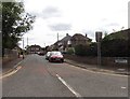
5
St Michael's Avenue, Yeovil
A residential road with speed bumps.
Image: © Robin Webster
Taken: 3 Nov 2018
0.25 miles