IMAGES TAKEN NEAR TO
Tower Road, YEOVIL, BA21 4NG
Introduction
This page details the photographs taken nearby to Tower Road, BA21 4NG by members of the Geograph project.
The Geograph project started in 2005 with the aim of publishing, organising and preserving representative images for every square kilometre of Great Britain, Ireland and the Isle of Man.

There are currently over 7.5m images from over14,400 individuals and you can help contribute to the project by visiting https://www.geograph.org.uk
Image Map (7 Images)


Getting Data...Please wait
Leaflet Map data © OpenStreetMap
Images are licensed for reuse under creativecommons.org/licenses/by-sa/2.0
Notes
- Clicking on the map will re-center to the selected point.
- The higher the marker number, the further away the image location is from the centre of the postcode.
Image Listing (7 Images Found)
Images are licensed for reuse under creativecommons.org/licenses/by-sa/2.0
Image
Details
Distance
3

Ordnance Survey Flush Bracket 10810
This can be found on the roadside wall of Turnpike Cottage, Longcroft.
For more detail see : http://www.bench-marks.org.uk/bm18803
Image: © Peter Wood
Taken: 31 Mar 2014
0.15 miles
4
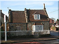
Brickyard Lane Toll House, Mudford Lane, Yeovil
Toll House by the A359, in the parish of Yeovil Without, Turnpike Cottage, 198, Mudford Lane, BA21.
Grade II listed.
List Entry Number: 1173931 https://historicengland.org.uk/listing/the-list/list-entry/1173931
Surveyed
Milestone Society National ID: SO.YEO02
Image: © Alan Rosevear
Taken: 10 Feb 2008
0.15 miles

6
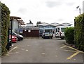
Entrance, Fairmead Community Special School
Image: © Roger Cornfoot
Taken: 18 Jul 2018
0.16 miles