IMAGES TAKEN NEAR TO
North Terrace, YEOVIL, BA21 4JP
Introduction
This page details the photographs taken nearby to North Terrace, BA21 4JP by members of the Geograph project.
The Geograph project started in 2005 with the aim of publishing, organising and preserving representative images for every square kilometre of Great Britain, Ireland and the Isle of Man.

There are currently over 7.5m images from over14,400 individuals and you can help contribute to the project by visiting https://www.geograph.org.uk
Image Map (Loading...)


Getting Data...Please wait
Leaflet Map data © OpenStreetMap
Images are licensed for reuse under creativecommons.org/licenses/by-sa/2.0
Notes
- Clicking on the map will re-center to the selected point.
- The higher the marker number, the further away the image location is from the centre of the postcode.
Image Listing (22 Images Found)
Images are licensed for reuse under creativecommons.org/licenses/by-sa/2.0
Image
Details
Distance
1
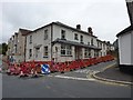
Yet another former Yeovil pub
This former public house at the intersection of Eastland and Highfield Roads is shown in the process of being converted into flats.
Image: © Steve Barnes
Taken: 12 Aug 2009
0.06 miles
2
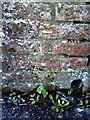
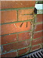
Benchmark on roadside face of wall at junction of nos. 19 and 21 Mount Pleasant
Ordnance Survey cut mark benchmark described on the Bench Mark Database at http://www.bench-marks.org.uk/bm37106
Image: © Roger Templeman
Taken: 19 Feb 2011
0.08 miles
3
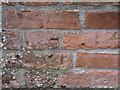
Worn benchmark on roadside face of wall at junction of nos. 19 and 21 Mount Pleasant, Yeovil
Ordnance Survey benchmark, described on database at http://www.bench-marks.org.uk/bm37106.
Image: © Becky Williamson
Taken: 29 Jun 2015
0.09 miles
5

Weathered benchmark on base of gatepost at entrance to St Michael & All Angels' Church
Ordnance Survey cut mark benchmark described on the Bench Mark Database at http://www.bench-marks.org.uk/bm37107
Image: © Roger Templeman
Taken: 19 Feb 2011
0.16 miles
6
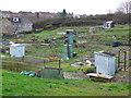
Allotments, Yeovil
These are on the eastern side of Yeovil in the most working class part of town
Image: © Nigel Mykura
Taken: 16 Jan 2008
0.16 miles
7

The Church of St Michael at Yeovil
Viewed from the road to the west.
Image: © Peter Wood
Taken: 31 Mar 2014
0.17 miles
8
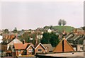
View across to Wyndham Hill from above Yeovil bus station
Looking from the very edge of the Quedam shopping centre by the escalator down to Glovers Walk and the bus station. Wyndham Hill is instantly recognisable with its four trees on top, and offers great views over the whole of Yeovil.
Image: © Jim Champion
Taken: Unknown
0.17 miles
9
Benchmark on #8 Eastville
Ordnance Survey cut mark benchmark described on the Bench Mark Database at http://www.bench-marks.org.uk/bm37105
Image: © Roger Templeman
Taken: 19 Feb 2011
0.18 miles
10
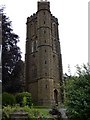
St Michael's Church, Yeovil
By a strange coincidence this church is on St Michael's Avenue.
Image: © Steve Barnes
Taken: 12 Aug 2009
0.19 miles