IMAGES TAKEN NEAR TO
Sherborne Road, YEOVIL, BA21 4HF
Introduction
This page details the photographs taken nearby to Sherborne Road, BA21 4HF by members of the Geograph project.
The Geograph project started in 2005 with the aim of publishing, organising and preserving representative images for every square kilometre of Great Britain, Ireland and the Isle of Man.

There are currently over 7.5m images from over14,400 individuals and you can help contribute to the project by visiting https://www.geograph.org.uk
Image Map (Loading...)


Getting Data...Please wait
Leaflet Map data © OpenStreetMap
Images are licensed for reuse under creativecommons.org/licenses/by-sa/2.0
Notes
- Clicking on the map will re-center to the selected point.
- The higher the marker number, the further away the image location is from the centre of the postcode.
Image Listing (64 Images Found)
Images are licensed for reuse under creativecommons.org/licenses/by-sa/2.0
Image
Details
Distance
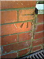
1
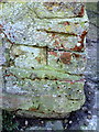
Benchmark on angle of wall at #13 St Michaels Avenue
Ordnance Survey cut mark benchmark described on the Bench Mark Database at http://www.bench-marks.org.uk/bm37109
Image: © Roger Templeman
Taken: 19 Feb 2011
0.06 miles
2
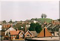
View across to Wyndham Hill from above Yeovil bus station
Looking from the very edge of the Quedam shopping centre by the escalator down to Glovers Walk and the bus station. Wyndham Hill is instantly recognisable with its four trees on top, and offers great views over the whole of Yeovil.
Image: © Jim Champion
Taken: Unknown
0.09 miles
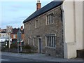
3
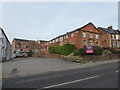
89 Sherborne Road, Yeovil
The building with the fine doorway on the right is 89 Sherborne Road and now appears to be office to let. The aerial view suggests it was once Prenax Ltd - a publications and subscription management company.
Image: © Chris Allen
Taken: 27 Dec 2016
0.10 miles
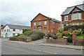
4

Former Hall
The two dwellings that this former hall now make up give their addresses and 1 & 2 The Old Hall.
Image: © Steve Barnes
Taken: 12 Aug 2009
0.10 miles
5
89 Sherborne Road, Yeovil
First mapped in the early 20th century as a 'Hall' later as a 'Works', it now appears to be office premises.
Image: © Robin Webster
Taken: 3 Nov 2018
0.10 miles
6
Benchmark on #8 Eastville
Ordnance Survey cut mark benchmark described on the Bench Mark Database at http://www.bench-marks.org.uk/bm37105
Image: © Roger Templeman
Taken: 19 Feb 2011
0.10 miles
7
The Glovers Arms
Following two fires the Glovers Arms is now flats.
Image: © Steve Barnes
Taken: 23 Jul 2009
0.11 miles

9

Four Lime trees Wyndham Hill
These old trees stand at the summit of the hill commanding a spectacular view of Yeovil and surrounding area. Their trunks are nearly all hollow.
Image: © Sarah Smith
Taken: 5 May 2009
0.12 miles
10

Yeovil: Wyndham Hill
Picture taken from Ninesprings of sledging activity after a night of heavy snow.
Image: © Mr Eugene Birchall
Taken: 3 Feb 2009
0.13 miles