IMAGES TAKEN NEAR TO
Vagg Hill, YEOVIL, BA21 3PT
Introduction
This page details the photographs taken nearby to Vagg Hill, BA21 3PT by members of the Geograph project.
The Geograph project started in 2005 with the aim of publishing, organising and preserving representative images for every square kilometre of Great Britain, Ireland and the Isle of Man.

There are currently over 7.5m images from over14,400 individuals and you can help contribute to the project by visiting https://www.geograph.org.uk
Image Map (Loading...)


Getting Data...Please wait
Leaflet Map data © OpenStreetMap
Images are licensed for reuse under creativecommons.org/licenses/by-sa/2.0
Notes
- Clicking on the map will re-center to the selected point.
- The higher the marker number, the further away the image location is from the centre of the postcode.
Image Listing (9 Images Found)
Images are licensed for reuse under creativecommons.org/licenses/by-sa/2.0
Image
Details
Distance
5

Mobile Phone Mast on Tintinhull Road
14 metre high mast operated by Orange near Vagg Farm.
Image: © The Mallick Family
Taken: 29 Jun 2006
0.11 miles
7
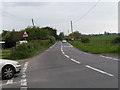
Roman Road, Yeovil
This is the old Roman Road from Ilchester looking back from Thorne Lane. The area is scheduled for development with the extension of the Abbey Manor Estate
Image: © Brian Roberts
Taken: 23 Jul 2008
0.19 miles
8
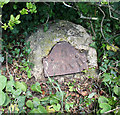
Old Milestone by Tintinhull Road, north of Yeovil
Metal plate attached to stone post by the UC road, in parish of Yeovil Without (South Somerset District), Tintinhull Road, Coppitts Rise, between equestrian centre and Vagg Farm crossroads, under hedge beside road, on North side of road. Yeovil roll top iron plate, erected by the Yeovil turnpike trust in the 18th century.
Inscription reads:-
: II / YEOVIL : : (V¾ / MARTOCK) :
Somerset HER.
HER number: 19540 https://www.heritagegateway.org.uk/Gateway/Results_Single.aspx?uid=19540&resourceID=100
Milestone Society National ID: SO_YVTH02
Image: © Alan Rosevear
Taken: 12 Apr 2011
0.19 miles
9
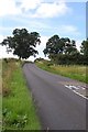
Vagg Hollow near Yeovil
These holloways are characteristic of South Somerset because of the geology which consists of Yeovil/Bridport sands
Image: © Nigel Mykura
Taken: 24 Jan 2008
0.24 miles