IMAGES TAKEN NEAR TO
Skinners Hill, BATH, BA2 0PX
Introduction
This page details the photographs taken nearby to Skinners Hill, BA2 0PX by members of the Geograph project.
The Geograph project started in 2005 with the aim of publishing, organising and preserving representative images for every square kilometre of Great Britain, Ireland and the Isle of Man.

There are currently over 7.5m images from over14,400 individuals and you can help contribute to the project by visiting https://www.geograph.org.uk
Image Map
Images are licensed for reuse under creativecommons.org/licenses/by-sa/2.0
Notes
- Clicking on the map will re-center to the selected point.
- The higher the marker number, the further away the image location is from the centre of the postcode.
Image Listing (25 Images Found)
Images are licensed for reuse under creativecommons.org/licenses/by-sa/2.0
Image
Details
Distance
1
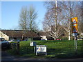
National Osteoporosis Society in Camerton
The National Osteoporosis Society was founded in 1986 by Professor Allan Dixon and Linda Edwards, taking over part of the old Manor Farm,
Image: © Neil Owen
Taken: 30 Jan 2019
0.04 miles
2
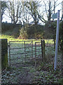
A short hop across the grass
This short footpath actually crosses the original Skinner's Hill road - now grass!
Image: © Neil Owen
Taken: 30 Jan 2019
0.05 miles
3
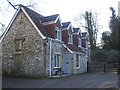
The Old Coach House
In earlier times this house was on the steep road that ran down into Camerton village; the modern road is a short distance to the west of it now. On the corner of the building is an unusual feature - a pair of benchmarks! See Image] for a closer look at this rare happening.
Image: © Neil Owen
Taken: 30 Jan 2019
0.05 miles
4
Doubled up in Camerton
An unusual occurrence: a pair of cut benchmarks in close proximity. The OS database only records the one mark, although it may be that one was considered unreliable for some reason. Interestingly, old maps show the mark over many years but with a slightly different height given between 1886 and 1904 - more so than other marks nearby. Perhaps this indicates the appearance of the second mark?
See https://www.bench-marks.org.uk/bm104077 for the entry in the Benchmark Database, and Image] for a wider view of the old building.
Image: © Neil Owen
Taken: 30 Jan 2019
0.05 miles
5

Thatched Cottage at the entrance to the Court
A bright display of snowdrops and crocuses in the grounds of the old cottage, overlooking the entrance to Camerton Court.
Image: © Neil Owen
Taken: 30 Jan 2019
0.06 miles
6
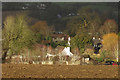
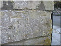
Farm and houses, Camerton
A detail of Image This shows Manor Farm, with Thatched Cottage the appropriately-named listed building https://historicengland.org.uk/listing/the-list/list-entry/1135777 to the right, largely obscured by a tree.
Image: © Derek Harper
Taken: 6 Dec 2019
0.07 miles
7
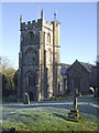
St Peter's, Camerton
This church in the proximity of Camerton Court dates from the fifteenth century and is Grade I listed. A well appointed benchmark can be found on the south facing wall of the tower - see Image
Image: © Neil Owen
Taken: 30 Jan 2019
0.11 miles
8
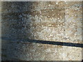
Accuracy and authenticity on St Peter's
A cut benchmark, as listed in the Benchmark Database: https://www.bench-marks.org.uk/bm104078 , on the south wall of St Peter's church tower. Not content with the mark, the height above sea level (342 ft) is also inscribed in the stonework. Sadly the lighting does not enhance the clarity. See Image] for a wider view.
Image: © Neil Owen
Taken: 30 Jan 2019
0.11 miles
9
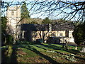
Winter sunshine and snowdrops at St Peter's
Some frosty but clear air bathes this hillside church.
Image: © Neil Owen
Taken: 30 Jan 2019
0.11 miles
10
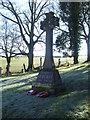
Camerton war memorial
A cross, erected by public subscription, bearing the names of some six local men who fell in WWI and three in WWII. "Faithful unto death."
Image: © Neil Owen
Taken: 30 Jan 2019
0.11 miles