IMAGES TAKEN NEAR TO
Red Hill, BATH, BA2 0PB
Introduction
This page details the photographs taken nearby to Red Hill, BA2 0PB by members of the Geograph project.
The Geograph project started in 2005 with the aim of publishing, organising and preserving representative images for every square kilometre of Great Britain, Ireland and the Isle of Man.

There are currently over 7.5m images from over14,400 individuals and you can help contribute to the project by visiting https://www.geograph.org.uk
Image Map
Images are licensed for reuse under creativecommons.org/licenses/by-sa/2.0
Notes
- Clicking on the map will re-center to the selected point.
- The higher the marker number, the further away the image location is from the centre of the postcode.
Image Listing (42 Images Found)
Images are licensed for reuse under creativecommons.org/licenses/by-sa/2.0
Image
Details
Distance
1
From the coal statue to the coal canal (1)
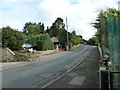
Rush hour in Camerton
Image: © Basher Eyre
Taken: 14 Sep 2013
0.01 miles
3
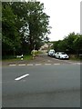
Looking from Red Hill across to Canal View
Image: © Basher Eyre
Taken: 16 Sep 2012
0.03 miles

5

Green to black to green
This heritage trail entrance is a modern nature reserve and largely populated by greenery. In the past it was equally green until the coal mining industry came along. There then followed a couple of centuries of extraction, and this spot was the entrance to the Old Pit - and the massive intrusion that it brought to the previously quiet village. Now it's returned to the peace and quiet of before, with a trail for visitors to enjoy.
Image: © Neil Owen
Taken: 30 Jan 2019
0.03 miles
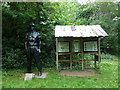
6
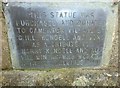
Plaque below the statue of a miner at Camerton
See http://www.geograph.org.uk/photo/3134730
Image: © Basher Eyre
Taken: 16 Sep 2012
0.03 miles
7
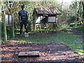
The big miner
The Old Pit colliery used to be here during its career of coal extraction from 1781 to the mid-1890s. It provided thousands of tons of good house and gas coal but later acceded to the New Pit when that opened up better seams. By 1937 the Old Pit was closed and the shaft capped - marked by the iron plating in the foreground.
The large black statue in the background is one that stood in the Festival of Britain in 1951.
The area now known as Camerton Batch Local Nature Reserve stands largely on the old spoil heaps that were produced over the years. Nature has been invited back and many examples of wildlife have taken the opportunity.
Image: © Neil Owen
Taken: 30 Jan 2019
0.03 miles
8
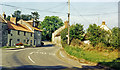
Camerton: site of station, 1987
View northward, across the course of the GWR Limpley Stoke (right) - Hallatrow (left) branch, which was closed way back on 21/9/25 - after only 15 years, to goods from 15/2/51. No trace seems to be left.
Image: © Ben Brooksbank
Taken: 5 May 1987
0.04 miles
9
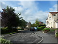
From the coal statue to the coal canal (2)
Residential road in Camerton
Image: © Basher Eyre
Taken: 14 Sep 2013
0.05 miles
10
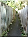
From the coal statue to the coal canal (4)
Path from one residential area to another
Image: © Basher Eyre
Taken: 14 Sep 2013
0.06 miles