IMAGES TAKEN NEAR TO
High Street, BATH, BA2 0HT
Introduction
This page details the photographs taken nearby to High Street, BA2 0HT by members of the Geograph project.
The Geograph project started in 2005 with the aim of publishing, organising and preserving representative images for every square kilometre of Great Britain, Ireland and the Isle of Man.

There are currently over 7.5m images from over14,400 individuals and you can help contribute to the project by visiting https://www.geograph.org.uk
Image Map
Images are licensed for reuse under creativecommons.org/licenses/by-sa/2.0
Notes
- Clicking on the map will re-center to the selected point.
- The higher the marker number, the further away the image location is from the centre of the postcode.
Image Listing (59 Images Found)
Images are licensed for reuse under creativecommons.org/licenses/by-sa/2.0
Image
Details
Distance
1
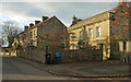
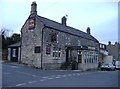
Houses on High Street, Timsbury
On the left is Pitfour Terrace, shown in Image On the right is the mid C17 Pitfour House https://historicengland.org.uk/listing/the-list/list-entry/1129599 , with information on the former occupants at http://www.timsbury.org.uk/pitfour-house/ . The gatepiers with ball finials, rather hidden in shadow on the left, are also listed https://historicengland.org.uk/listing/the-list/list-entry/1136004 .
Image: © Derek Harper
Taken: 9 Dec 2019
0.02 miles
2
2007 : High Street, Timsbury
Timsbury is mentioned in the Domesday Book.
From about 1800 it was a mining town in the North Somerset coalfield, this has now ceased.
St. Mary's Church is at the far end of High Street.
Image: © Maurice Pullin
Taken: 10 Jul 2007
0.02 miles
3
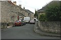
Pitfour Terrace, Timsbury
A terrace of five on the High Street.
Image: © Derek Harper
Taken: 9 Dec 2019
0.03 miles
4

2009 : Church Hill Timsbury
The Guss and Crook public house is to the right.
Image: © Maurice Pullin
Taken: 20 Dec 2009
0.03 miles
6

2009 : Sign of the "Guss & Crook"
The inn sign of The Guss and Crook gives some idea of the hardships endured by miners of the Somerset Coal Field in former days.
Pit ponies were used for this work in other parts of the country.
---- ooOoo ----
"The oldest member of the Timsbury community still living in the village has died at the Laurels Nursing Home at the age of 98.
Les Bridges was born at Hobbs Wall, Farmborough, on April 15, 1910.
Much of his working life saw him employed in the mines, principally at Pensford, where he used to wear the guss and crook."
In his younger days, Mr Bridges was a talented footballer for both Farmborough and Timsbury and represented the county."
The above was extracted from: http://www.thisissomerset.co.uk/news/Life-Les-Bridges/article-651505-detail/article.html
Image: © Maurice Pullin
Taken: 20 Dec 2009
0.04 miles
8
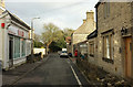
High Street, Timsbury
On the immediate right is the former post office. The High Street leads into The Square, which is roughly triangular.
Image: © Derek Harper
Taken: 9 Dec 2019
0.04 miles
9
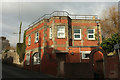
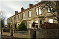
House on Church Hill, Timsbury
A distinctive flat-roofed brick house just above the former Guss and Crook pub; both are visible in Image
Image: © Derek Harper
Taken: 9 Dec 2019
0.04 miles
10
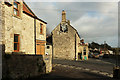
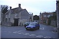
Corner in Timsbury
Not for the first time, my very early Explorer sheet from the 90s misled me into thinking there was a pub here. Clearly Dray Cottage (centre), by the junction of Church Hill (left) and South Road, was once a pub (originally the New Inn but later the Guss and Crook https://www.flickr.com/photos/77751183@N07/33347771205 ), but is now a clock restorer's.
Image: © Derek Harper
Taken: 9 Dec 2019
0.05 miles