IMAGES TAKEN NEAR TO
Greenvale Drive, BATH, BA2 0HP
Introduction
This page details the photographs taken nearby to Greenvale Drive, BA2 0HP by members of the Geograph project.
The Geograph project started in 2005 with the aim of publishing, organising and preserving representative images for every square kilometre of Great Britain, Ireland and the Isle of Man.

There are currently over 7.5m images from over14,400 individuals and you can help contribute to the project by visiting https://www.geograph.org.uk
Image Map
Images are licensed for reuse under creativecommons.org/licenses/by-sa/2.0
Notes
- Clicking on the map will re-center to the selected point.
- The higher the marker number, the further away the image location is from the centre of the postcode.
Image Listing (14 Images Found)
Images are licensed for reuse under creativecommons.org/licenses/by-sa/2.0
Image
Details
Distance
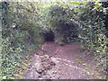
2

Mill Lane
Looking downhill just before the byway becomes a sunken lane in a deep gulley.
Image: © James Ayres
Taken: 18 Aug 2012
0.20 miles
3
Mill Lane
Looking downhill from close to where the footpath crosses the byway
Image: © James Ayres
Taken: 28 Aug 2011
0.22 miles
4
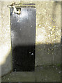
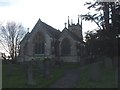
Well-watered benchmark
The mark on St Mary's church won't be running dry, it seems. See http://www.bench-marks.org.uk/bm64179 for the entry in the Benchmark Database and Image] for a view of the tower.
Image: © Neil Owen
Taken: 9 Feb 2015
0.23 miles
5
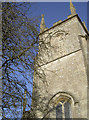
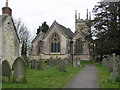
St Mary's tower
Built in 1826, the parish church tower contains seven bells: they range in weight from about 6cwt to the Tenor of about 12cwt, and were last rehung at the beginning of the last century. The Sanctus bell is a separate seventh bell salvaged from the former Primary School in South Road where it used to remind the laggardly that they must soon be at their desks. It now performs a similar duty for today’s congregation. See Image] for a full view.
Image: © Neil Owen
Taken: 9 Feb 2015
0.23 miles
8
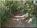
Mill Lane BOAT
Looking uphill at the point where the footpath crosses the byway
Image: © James Ayres
Taken: 28 Aug 2011
0.23 miles
10

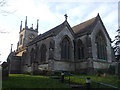
An early showing
St Mary's church dates from possibly Norman times, although the current building was created in 1826. The surprisingly warm previous year and the fairly kind winter thus far has allowed the snowdrops and crocuses a quick start. See Image] for more.
Image: © Neil Owen
Taken: 9 Feb 2015
0.23 miles