IMAGES TAKEN NEAR TO
Tunley Road, BATH, BA2 0EE
Introduction
This page details the photographs taken nearby to Tunley Road, BA2 0EE by members of the Geograph project.
The Geograph project started in 2005 with the aim of publishing, organising and preserving representative images for every square kilometre of Great Britain, Ireland and the Isle of Man.

There are currently over 7.5m images from over14,400 individuals and you can help contribute to the project by visiting https://www.geograph.org.uk
Image Map
Images are licensed for reuse under creativecommons.org/licenses/by-sa/2.0
Notes
- Clicking on the map will re-center to the selected point.
- The higher the marker number, the further away the image location is from the centre of the postcode.
Image Listing (17 Images Found)
Images are licensed for reuse under creativecommons.org/licenses/by-sa/2.0
Image
Details
Distance
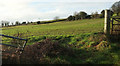
1
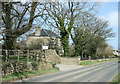
2008 : North Hill Farm
Near Tunley on the B3115.
Image: © Maurice Pullin
Taken: 1 Apr 2008
0.00 miles
2
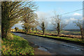
Tunley Road
The B3115 passing North Hill Farm. On the right is a view over the Cam Brook valley.
Image: © Derek Harper
Taken: 6 Dec 2019
0.05 miles
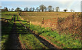
3
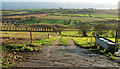
Track to Withyditch Lane
The top of the track (not a right of way) shown in Image], with the line of trees on the left shown in Image Down below is the Cam Brook valley.
Image: © Derek Harper
Taken: 6 Dec 2019
0.11 miles
4
Towards the Cam Brook valley
Looking right from where Image] was taken.
Image: © Derek Harper
Taken: 6 Dec 2019
0.11 miles
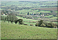
5
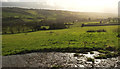
Hillside by Withyditch Lane
Looking left from Image] across an arable field (currently under grass) on the north side of the lane.
Image: © Derek Harper
Taken: 6 Dec 2019
0.15 miles
6
Track and farmland by Withyditch Lane
The track links the lane to the B3115 Tunley Road (lined by the trees on the horizon), but is not a right of way.
Image: © Derek Harper
Taken: 6 Dec 2019
0.19 miles
7
2008 : View from Tunley Road
Looking into the Cam Brook valley. Dunkerton is at the bottom.
Image: © Maurice Pullin
Taken: 1 Apr 2008
0.19 miles
8
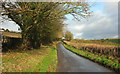
Withyditch Lane
The lane climbs from where http://www.geograph.org.uk/search.php?i=107037948 were taken, to the B3115 at Longhouse. The trees on the left can be seen in Image
Image: © Derek Harper
Taken: 6 Dec 2019
0.19 miles
9
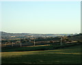
2009 : North east from the B3115 Tunley Road
Mostly pasture land.
The view takes in the suburbs of Bath on the slopes to Lansdown. It is just possible to see Little Solsbury Hill right of centre Image
Image: © Maurice Pullin
Taken: 20 Dec 2009
0.20 miles
10
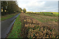
Withyditch Lane
A similar view to Image from the other side of the road.
Image: © Derek Harper
Taken: 6 Dec 2019
0.20 miles