IMAGES TAKEN NEAR TO
Sunnyside Gardens, Lippiatt Lane, BATH, BA2 0BQ
Introduction
This page details the photographs taken nearby to Sunnyside Gardens, Lippiatt Lane, BA2 0BQ by members of the Geograph project.
The Geograph project started in 2005 with the aim of publishing, organising and preserving representative images for every square kilometre of Great Britain, Ireland and the Isle of Man.

There are currently over 7.5m images from over14,400 individuals and you can help contribute to the project by visiting https://www.geograph.org.uk
Image Map
Images are licensed for reuse under creativecommons.org/licenses/by-sa/2.0
Notes
- Clicking on the map will re-center to the selected point.
- The higher the marker number, the further away the image location is from the centre of the postcode.
Image Listing (53 Images Found)
Images are licensed for reuse under creativecommons.org/licenses/by-sa/2.0
Image
Details
Distance
1
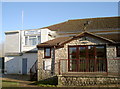
Timsbury Cricket Club
Attached to the Conygre Hall and suitably white. Timsbury are in the Bristol & District Cricket Association Senior Division for 2015 and run three teams.
One historical item worth mentioning was the club's innovative method of drying a wet wicket in 1983: former Somerset C.C.C. captain, Brian Rose, was due to appear in a testimonial match but the weather leading up to it was foul. Club chairman Eric Nott half-heartedly claimed they ought to get a helicopter to dry it out. Somehow the idea was taken seriously and thanks to sponsor involvement a helicopter arrived to hover above the batting strip!
Image: © Neil Owen
Taken: 9 Feb 2015
0.04 miles
2
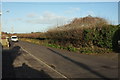
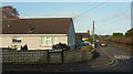
Lippiatt Lane
Opposite the last house on the east side of the lane; housing continues on the west (left) side.
Image: © Derek Harper
Taken: 9 Dec 2019
0.04 miles
3
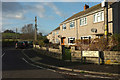
Cul-de-sac, Lippiatt Lane
The addresses of houses in this close is still Lippiatt Lane. The hill in the background is The Sleight.
Image: © Derek Harper
Taken: 9 Dec 2019
0.05 miles
4
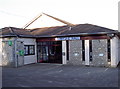
Conygre Hall
Timsbury was, for much of its latter history, a mining village. With the easing of legal restrictions in the 1920s to provide a means of help and assistance for miners, a plot of land was acquired as a recreation ground. Following concerted fund-raising, the hall was built and opened on 26th May, 1973. The Conygre Trust (in recognition of the old Conygre Colliery) was set up in 2005 to run the various indoor and outdoor facilities.
Image: © Neil Owen
Taken: 9 Feb 2015
0.05 miles
5
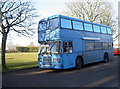
Big Blue Bus
This is Lottie, the familiar playbus that tours around the local community to offer safe play sessions to the children. Today Lottie is in Timsbury's Conygre Hall park.
The first bus was started by enthusiastic volunteers in 1985; a bequest by Dorothy Melhuish set up a fund to buy an old double decker in Bath. 'Bertha' began as a mobile clinic, but with further input by other organisations she also offered a coffee bar, advice and exhibition space. In 1991, the organisation separated and achieved charitable status. 'Bertha' became too frail and was replaced by 'Doris' in 1994 and sought funding from many different sources, including some television appearances. The group running the bus also changed again in 1999, renaming itself as the Community Bus and reflected the increased range it covered.
However, it became clear that more needed doing and hence a third bus was purchased in 2003; funded partly from the National Lottery, she is named 'Lottie'. The group reorganised once more in order to put itself in line for more help from the various financial possibilities. The original setup also went, dissolving the old unincorporated charity and transferring all assets and activities to a new Charitable Incorporated Organisation (CIO).
The Big Blue Bus is a double decker, fully converted as a mobile community centre, kitted out with a kitchen, toilet, 240V electricity, lighting, heating, carpeted seating area, sensory toys, library and messy play area. It primarily allows children of school age to play in a safe environment; it also allows parents a chance to brush up on vital skills too.
Image: © Neil Owen
Taken: 9 Feb 2015
0.06 miles
6
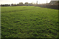
Grass field, Timsbury
Looking the other way from Image
Image: © Derek Harper
Taken: 9 Dec 2019
0.06 miles
7
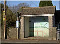
A landscape whilst waiting
A bus shelter, complete with a pleasing landscape.
Image: © Neil Owen
Taken: 9 Feb 2015
0.06 miles
8
Lippiatt Lane
Seen across its junction with North Road.
Image: © Derek Harper
Taken: 9 Dec 2019
0.07 miles
9
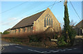
Congregational Church, Timsbury
Looking right from Image The church, dating from 1928, is also shown at Image http://www.timsbury.org.uk/congregational-church/
Image: © Derek Harper
Taken: 9 Dec 2019
0.07 miles
10
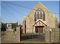
Timsbury Congregational Church
The village faithful used to have to travel elsewhere to worship before 1825, when a local landowning church-goer provided land to build a new church on Maggs Hill. Despite the popularity, the church started to show signs of wear and tear; by 1881, almost the whole of it needed repairs or replacement - even the floorings were renewed. Moves were made to build another new church - here in North Road - and by 1928 monies had been forwarded to start work. On Saturday 21st July 1828, the foundation stone was laid at a cost of £1,763 18s, and the work carried out by W.J.Kew of Bishopsworth. However, the money was a little short of what was required; a further £1,000 had to be raised, which was eventually achieved by 1938.
Image: © Neil Owen
Taken: 9 Feb 2015
0.07 miles