IMAGES TAKEN NEAR TO
Hillgrove Avenue, YEOVIL, BA20 2LP
Introduction
This page details the photographs taken nearby to Hillgrove Avenue, BA20 2LP by members of the Geograph project.
The Geograph project started in 2005 with the aim of publishing, organising and preserving representative images for every square kilometre of Great Britain, Ireland and the Isle of Man.

There are currently over 7.5m images from over14,400 individuals and you can help contribute to the project by visiting https://www.geograph.org.uk
Image Map
Images are licensed for reuse under creativecommons.org/licenses/by-sa/2.0
Notes
- Clicking on the map will re-center to the selected point.
- The higher the marker number, the further away the image location is from the centre of the postcode.
Image Listing (35 Images Found)
Images are licensed for reuse under creativecommons.org/licenses/by-sa/2.0
Image
Details
Distance
1
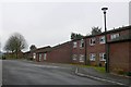
Flats and Houses at Windermere Rd
This residential road is a small cul-de-sac on the south side of Yeovil close to the top of Hendford Hill
Image: © Nigel Mykura
Taken: 29 Jan 2009
0.06 miles
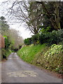
2
Turner's Barn Lane in the spring
A road full of scented and colourful blossom in the spring. Turner's Barn Lane runs from the upper part of East Coker Road and continues through to Sandhurst Road.
Image: © Sarah Smith
Taken: 31 Mar 2009
0.09 miles
3

Old Milestone by the A30, West Coker Road, Yeovil
Metal plate attached to stone post by the A30, in parish of YEOVIL (SOUTH SOMERSET District), West Coker Road, by No. 31, West of junction with Hillgrove Avenue, embedded in stone wall, on South side of road. Yeovil roll top iron plate, erected by the Yeovil turnpike trust in the 18th century.
Inscription reads:-
I
YEOVIL
Carved benchmark on lower right face.
Grade II listed.
List Entry Number: 1417784 https://historicengland.org.uk/listing/the-list/list-entry/1417784
Milestone Society National ID: SO_YVCW01.
Image: © Alan Rosevear
Taken: 27 Apr 2011
0.09 miles
4
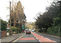
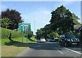
A30 entering Yeovil
Down the hill is Horsey Roundabout
Image: © John Firth
Taken: 12 Apr 2013
0.09 miles
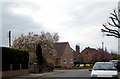
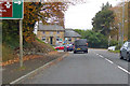
5

Houses on Sandhurst Road, Yeovil
Looking in the opposite direction from where Image] was taken. The junction is with Turner's Barn Lane.
Image: © Derek Harper
Taken: 27 Apr 2019
0.13 miles
6
East Coker Road - Yeovil
The lower end of East Coker Road is narrow but pretty - note the primroses. It turns off the main Dorchester Road and cuts down to near the bottom of Sandhurst Road. Not very good for traffic with a blind corner and hardly any passing space.
Image: © Sarah Smith
Taken: 31 Mar 2009
0.14 miles

9
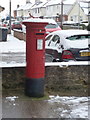
Yeovil: postbox № BA20 27, West Coker Road
This George V-reign postbox stands on the corner of West Coker Road (the A30) and Sandhurst Road (visible behind), on the forecourt of Sandhurst Post Office. The office was previously called West Coker Road but changed its name to Sandhurst on 1 December 1996 for no immediately apparent reason. The postbox has the fitting for an old-fashioned post office direction sign on its top.
Image: © Chris Downer
Taken: 19 Jan 2013
0.15 miles
10
Quicksilver Roundabout and the Quicksilver Mail, Yeovil
The pub is named after the Quicksilver Mail coach that plied between London and Falmouth in the mid 19th century. The roundabout is of course named after the pub.
Image: © Robin Webster
Taken: 3 Nov 2018
0.16 miles