IMAGES TAKEN NEAR TO
West Coker Road, YEOVIL, BA20 2JD
Introduction
This page details the photographs taken nearby to West Coker Road, BA20 2JD by members of the Geograph project.
The Geograph project started in 2005 with the aim of publishing, organising and preserving representative images for every square kilometre of Great Britain, Ireland and the Isle of Man.

There are currently over 7.5m images from over14,400 individuals and you can help contribute to the project by visiting https://www.geograph.org.uk
Image Map
Images are licensed for reuse under creativecommons.org/licenses/by-sa/2.0
Notes
- Clicking on the map will re-center to the selected point.
- The higher the marker number, the further away the image location is from the centre of the postcode.
Image Listing (11 Images Found)
Images are licensed for reuse under creativecommons.org/licenses/by-sa/2.0
Image
Details
Distance
1
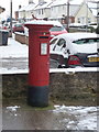
Yeovil: postbox № BA20 27, West Coker Road
This George V-reign postbox stands on the corner of West Coker Road (the A30) and Sandhurst Road (visible behind), on the forecourt of Sandhurst Post Office. The office was previously called West Coker Road but changed its name to Sandhurst on 1 December 1996 for no immediately apparent reason. The postbox has the fitting for an old-fashioned post office direction sign on its top.
Image: © Chris Downer
Taken: 19 Jan 2013
0.05 miles
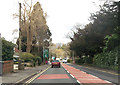
2
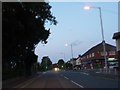
Dusk on West Coker Road
With the Post Office/Convenience Store on the right at the junction with Sandhurst Rd and opposite Forest Hill.
Image: © Steve Barnes
Taken: 1 Sep 2009
0.05 miles

4
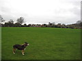
Playing Field, Sandhurst Road
A grey Christmas day in Yeovil - it was ever thus...
Image: © Rupert Fleetingly
Taken: 25 Dec 2011
0.10 miles
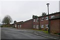
5

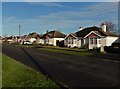
Houses on Sandhurst Road, Yeovil
Looking in the opposite direction from where Image] was taken. The junction is with Turner's Barn Lane.
Image: © Derek Harper
Taken: 27 Apr 2019
0.11 miles
6

Old Milestone by the A30, West Coker Road, Yeovil
Metal plate attached to stone post by the A30, in parish of YEOVIL (SOUTH SOMERSET District), West Coker Road, by No. 31, West of junction with Hillgrove Avenue, embedded in stone wall, on South side of road. Yeovil roll top iron plate, erected by the Yeovil turnpike trust in the 18th century.
Inscription reads:-
I
YEOVIL
Carved benchmark on lower right face.
Grade II listed.
List Entry Number: 1417784 https://historicengland.org.uk/listing/the-list/list-entry/1417784
Milestone Society National ID: SO_YVCW01.
Image: © Alan Rosevear
Taken: 27 Apr 2011
0.15 miles
8
Sandhurst Road, Yeovil
A similar scene to Image, which looks in the opposite direction.
Image: © Derek Harper
Taken: 27 Apr 2019
0.17 miles
9
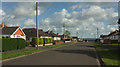
A30 entering Yeovil
Down the hill is Horsey Roundabout
Image: © John Firth
Taken: 12 Apr 2013
0.21 miles
10
Flats and Houses at Windermere Rd
This residential road is a small cul-de-sac on the south side of Yeovil close to the top of Hendford Hill
Image: © Nigel Mykura
Taken: 29 Jan 2009
0.23 miles