IMAGES TAKEN NEAR TO
Preston Grove, YEOVIL, BA20 2BQ
Introduction
This page details the photographs taken nearby to Preston Grove, BA20 2BQ by members of the Geograph project.
The Geograph project started in 2005 with the aim of publishing, organising and preserving representative images for every square kilometre of Great Britain, Ireland and the Isle of Man.

There are currently over 7.5m images from over14,400 individuals and you can help contribute to the project by visiting https://www.geograph.org.uk
Image Map
Images are licensed for reuse under creativecommons.org/licenses/by-sa/2.0
Notes
- Clicking on the map will re-center to the selected point.
- The higher the marker number, the further away the image location is from the centre of the postcode.
Image Listing (8 Images Found)
Images are licensed for reuse under creativecommons.org/licenses/by-sa/2.0
Image
Details
Distance
2
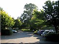
Carpark - Preston Grove Medical Centre
The carpark backs onto playing fields.
Image: © Sarah Smith
Taken: 26 Sep 2008
0.07 miles
3
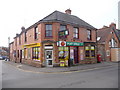
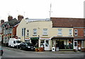
Yeovil: Orchard Street Post Office and postbox № BA20 8
This post office is marked on the 1:25,000 map as being on the other corner of Orchard Street, so it has probably moved within this general store in the last 10 years or so. The postbox is emptied finally at 5:30pm on weekdays and at noon on Saturdays.
Image: © Chris Downer
Taken: 24 Jan 2009
0.13 miles
4
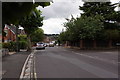
Crossroads near 74 Beer Street, Yeovil
Entering the crossroads from Westland Road, Beer Street is on the right with the shops (they are just about right on the gridline), Orchard Street runs from where the No Entry sign is, and on the left out of the photograph is West Street which runs up to Preston Grove and Huish.
Image: © Sarah Smith
Taken: 5 Feb 2009
0.16 miles

6
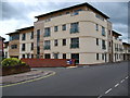
Richmond Place, Yeovil
This is a new development on the site of Tony Chant's garage in Huish.
Image: © Brian Roberts
Taken: 7 Jul 2008
0.21 miles
7

Benchmark on 'the Old Rectory', #5 West Park
Ordnance Survey cut mark benchmark described on the Bench Mark Database at http://www.bench-marks.org.uk/bm37123
Image: © Roger Templeman
Taken: 24 Feb 2011
0.21 miles
