IMAGES TAKEN NEAR TO
South Western Terrace, YEOVIL, BA20 1NT
Introduction
This page details the photographs taken nearby to South Western Terrace, BA20 1NT by members of the Geograph project.
The Geograph project started in 2005 with the aim of publishing, organising and preserving representative images for every square kilometre of Great Britain, Ireland and the Isle of Man.

There are currently over 7.5m images from over14,400 individuals and you can help contribute to the project by visiting https://www.geograph.org.uk
Image Map
Images are licensed for reuse under creativecommons.org/licenses/by-sa/2.0
Notes
- Clicking on the map will re-center to the selected point.
- The higher the marker number, the further away the image location is from the centre of the postcode.
Image Listing (100 Images Found)
Images are licensed for reuse under creativecommons.org/licenses/by-sa/2.0
Image
Details
Distance
1
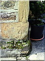
Benchmark on Newton Lodge, formerly a Turnpike Toll-House
Ordnance Survey cut mark benchmark described on the Bench Mark Database at http://www.bench-marks.org.uk/bm37104
Image: © Roger Templeman
Taken: 19 Feb 2011
0.01 miles
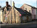
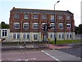
2
Newton Lodge, junction of Newton Road and South Western Terrace
The lodge was built about 1850 as Newton Road Toll House by the Yeovil & Ilchester Turnpike Trust. There is an OS benchmark Image on the near corner of the lodge, left of the pole of the no entry sign
Image: © Roger Templeman
Taken: 19 Feb 2011
0.01 miles
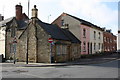
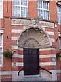
3
Old Toll House, Yeovil
Newton Lodge (Penstile House), 22, Newton Road, BA20 2RZ.
Grade II listed.
List Entry Number: 1056507 https://historicengland.org.uk/listing/the-list/list-entry/1056507
Surveyed
Milestone Society National ID: SO.YEO01
Image: © Alan Rosevear
Taken: 10 Feb 2008
0.01 miles
4
Converted building, Yeovil
In Old Station Road, this block with access to a storage floor has been converted from its former use. More recent buildings are adjacent
Image: © David Smith
Taken: 2 Oct 2014
0.01 miles
5
The Old Forge
Note that the windows are actually boarded up and for some reason painted to look like double glazing.
Image: © Steve Barnes
Taken: 23 Jul 2009
0.03 miles
6
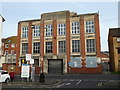
The Western Gazette
Offices and the Presses live behind this door
Image: © Steve Barnes
Taken: 23 Jul 2009
0.04 miles
7
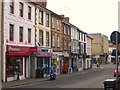
Lower Middle Street - Yeovil
Just a few metres down from the Western Gazette Building, this is the lower end of town. Central Road crosses the street at the bottom.
Image: © Sarah Smith
Taken: 21 Oct 2010
0.04 miles
8
Yeovil Town railway station (site), Somerset
Opened in 1861 as a joint Great Western Railway and London & South Western Railway station, it closed to passengers in 1966 and completely in 1968.
View south west towards Yeovil Hendford Halt and Taunton. Part of the old trackbed became a footpath and nature reserve.
Image: © Nigel Thompson
Taken: 27 Jun 2015
0.04 miles
9
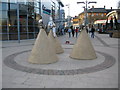
Industria Virtute Et Labore
A view looking west towards Old Station Road, showing the street art at the entrance to the cinema complex (out of shot at left). The inscription around the base of each cone reads " Industria Virtute Et Labore".
There is no information plaque, so I am unable to credit the sculptor.
Image: © Phil Williams
Taken: 10 Mar 2007
0.04 miles
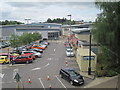
10
Former creamery, Yeovil
The inscription on the façade states Aplin & Barrett & the Western Counties Creameries. This building is derelict and part demolished. I obtained a view from round the back showing the demolition. This building is quite conspicuous but appears not to have been photographed before.
Image: © Chris Allen
Taken: 27 Dec 2016
0.04 miles