IMAGES TAKEN NEAR TO
St. Catherine, BATH, BA1 8HE
Introduction
This page details the photographs taken nearby to BA1 8HE by members of the Geograph project.
The Geograph project started in 2005 with the aim of publishing, organising and preserving representative images for every square kilometre of Great Britain, Ireland and the Isle of Man.

There are currently over 7.5m images from over14,400 individuals and you can help contribute to the project by visiting https://www.geograph.org.uk
Image Map
Images are licensed for reuse under creativecommons.org/licenses/by-sa/2.0
Notes
- Clicking on the map will re-center to the selected point.
- The higher the marker number, the further away the image location is from the centre of the postcode.
Image Listing (8 Images Found)
Images are licensed for reuse under creativecommons.org/licenses/by-sa/2.0
Image
Details
Distance
1
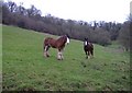
Shire horses
A pair of fine looking shire horses stand in pasture, on the southern side of St Catharine's valley.
Image: © Roger Cornfoot
Taken: 19 Jan 2007
0.17 miles
2
Footpath, St Catherine
The footpath heads steeply downhill towards St Catherine's Brook from Beeks Lane.
Image: © Maigheach-gheal
Taken: 21 Feb 2010
0.18 miles
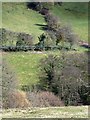
3
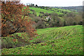
Downland above St Catherine's valley
Image: © Dr Duncan Pepper
Taken: 18 Oct 2015
0.19 miles
5
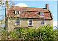
Beeks Mill at St Catherines End, near Bath
A grade II listed building. According to the Times December 2009 it was snapped up for 20 per cent above the guide price, despite having no central heating. Down by the near stream are what could be the remains of a mill, perhaps Monkswell dam upstream has made the stream smaller. Across the way is a cottage called paper mill cottage, so mills did once exist here.
Image: © Rick Crowley
Taken: 1 May 2010
0.21 miles
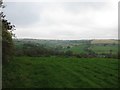
6
The Hermitage
Situated on the south side of the St Catharine's valley.
Image: © Roger Cornfoot
Taken: 19 Jan 2007
0.21 miles
7
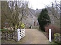
Limestone Link at Beek's Mill
The trail follows footpath LCA 33/10 down to St Catherine's Brook. Beek's Mill Cottage, in the centre with a mansard roof, is listed https://historicengland.org.uk/listing/the-list/list-entry/1129395 . It's getting dark soon after three, which is ridiculous.
Image: © Derek Harper
Taken: 7 Dec 2019
0.22 miles
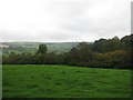
8
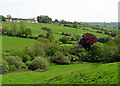
St Catherine's Valley
A view over the valley which carries St Catherine's brook. On the hill on the left is Beek's farm.
Image: © Sharon Loxton
Taken: 11 May 2008
0.25 miles