IMAGES TAKEN NEAR TO
Elmhurst Estate, BATH, BA1 7NR
Introduction
This page details the photographs taken nearby to Elmhurst Estate, BA1 7NR by members of the Geograph project.
The Geograph project started in 2005 with the aim of publishing, organising and preserving representative images for every square kilometre of Great Britain, Ireland and the Isle of Man.

There are currently over 7.5m images from over14,400 individuals and you can help contribute to the project by visiting https://www.geograph.org.uk
Image Map
Images are licensed for reuse under creativecommons.org/licenses/by-sa/2.0
Notes
- Clicking on the map will re-center to the selected point.
- The higher the marker number, the further away the image location is from the centre of the postcode.
Image Listing (32 Images Found)
Images are licensed for reuse under creativecommons.org/licenses/by-sa/2.0
Image
Details
Distance
1

2008 : Batheaston entertainments and Post Office
The Post Office squeezed between the George & Dragon and the Fat Friar.
Its Batheaston for the good life.
Not sure of the category in the end settled for "Post Office" as it is in the middle.
Image: © Maurice Pullin
Taken: 20 May 2008
0.18 miles
2
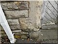
Ordnance Survey Cut Mark
This OS cut mark can be found on the building at Brow Hill. It marks a point 44.525m above mean sea level.
Image: © Adrian Dust
Taken: 24 May 2024
0.18 miles
3
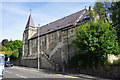
Congregational Chapel, Batheaston
Now converted into residential apartments.
Image: © Bill Boaden
Taken: 25 Jul 2016
0.18 miles

5
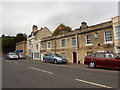
Houses on the Fosse Way
These houses and offices and shops are on the London Road East close to Stam Bridge where the old Roman road crosses St Catherines brook just before it reaches Batheaston where the road climbs up out of the valley of the Avon.
Image: © Nigel Mykura
Taken: 16 Sep 2012
0.19 miles
6
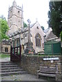
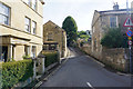
The steps up to St John the Baptist
Batheaston's church dates from the thirteenth century, although there are records that show a priest in the village in 1180. The war memorial stands close by.
Image: © Neil Owen
Taken: 8 Jun 2020
0.19 miles
7

Batheaston war memorial
The forty-four war dead of the old village of Batheaston are recorded in this memorial in the grounds of St John the Baptist. It was dedicated in a ceremony in 1920 and is partly based on a fifteenth century design.
Image: © Neil Owen
Taken: 8 Jun 2020
0.19 miles
8

2008 : The White Lion, Batheaston
On London Road near the turning for Colerne. The lion looks more like a shaggy dog.
Image: © Maurice Pullin
Taken: 20 May 2008
0.19 miles
9
Fosse Lane, Batheaston
A no-through route up the side of Banner Down.
Image: © Bill Boaden
Taken: 25 Jul 2016
0.20 miles
10

St John the Baptist
Church at Northend, Bath.
Image: © Wayland Smith
Taken: 11 Oct 2020
0.20 miles