IMAGES TAKEN NEAR TO
Brookside Close, BATH, BA1 7HW
Introduction
This page details the photographs taken nearby to Brookside Close, BA1 7HW by members of the Geograph project.
The Geograph project started in 2005 with the aim of publishing, organising and preserving representative images for every square kilometre of Great Britain, Ireland and the Isle of Man.

There are currently over 7.5m images from over14,400 individuals and you can help contribute to the project by visiting https://www.geograph.org.uk
Image Map
Images are licensed for reuse under creativecommons.org/licenses/by-sa/2.0
Notes
- Clicking on the map will re-center to the selected point.
- The higher the marker number, the further away the image location is from the centre of the postcode.
Image Listing (8 Images Found)
Images are licensed for reuse under creativecommons.org/licenses/by-sa/2.0
Image
Details
Distance
1

Eagle House
Eagle House, dated 1729 was home in the early 1900's to Mary Blathwayt who was part of the Suffragette movement and a lot of the members of the Women's Social and Political Union at one time stayed in the house.
Image: © Derek Hawkins
Taken: 4 Feb 2007
0.07 miles
2
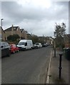
Batheaston North End
North End straggles up the valley with narrow roads and dead ends. Road access from the rest of Batheaston is restricted to the road that runs past the church; another possible route at the top of Catherine Way is blocked off. The former North End Inn was in this street until it shut in 2010.
Image: © HelenK
Taken: 15 Apr 2018
0.10 miles
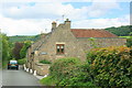
3
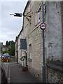
The end of the Northend Inn
This present-day house was originally a late seventeenth century house in Northend. It became an inn and served for many years, undergoing a number of alterations and changes. Now it has gone full circle and is a private residence, although the sign brackets remain.
Image: © Neil Owen
Taken: 8 Jun 2020
0.14 miles
4
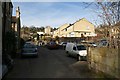
Northend
Part of Northend heading up the lower slopes of Little Solsbury.
Image: © Derek Hawkins
Taken: 4 Feb 2007
0.15 miles
5
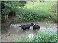
Cattle having a dip in St Catherine's Brook
Image: © Basher Eyre
Taken: 15 Sep 2013
0.21 miles
6
2008 : Fairhaven Cottages, St. Catherines Valley
The road through the valley as it passes Fairhaven Cottages.
Hope there is enough here and in other photos is this square to tempt you to visit St.Catherine's Valley, it gets better as it goes up and this is near the bottom. The road ends near Nimlet on the A46.
Image: © Maurice Pullin
Taken: 4 Jul 2008
0.23 miles
7
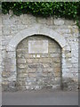
The old school entrance
The Batheaston Society has marked this blocked off entrance as from the old school 1818-59.
Image: © Neil Owen
Taken: 8 Jun 2020
0.24 miles
8
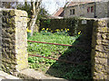
Pound, North End, Batheaston
In 1719 it cost 2/6d for a stray sheep to be released from here, horse or beast 5/- for every days trespass. Good idea. More information at http://users.bathspa.ac.uk/batheaston/be050.asp
Image: © Rick Crowley
Taken: 9 Apr 2010
0.24 miles