IMAGES TAKEN NEAR TO
Dafford Street, BATH, BA1 6SW
Introduction
This page details the photographs taken nearby to Dafford Street, BA1 6SW by members of the Geograph project.
The Geograph project started in 2005 with the aim of publishing, organising and preserving representative images for every square kilometre of Great Britain, Ireland and the Isle of Man.

There are currently over 7.5m images from over14,400 individuals and you can help contribute to the project by visiting https://www.geograph.org.uk
Image Map
Images are licensed for reuse under creativecommons.org/licenses/by-sa/2.0
Notes
- Clicking on the map will re-center to the selected point.
- The higher the marker number, the further away the image location is from the centre of the postcode.
Image Listing (37 Images Found)
Images are licensed for reuse under creativecommons.org/licenses/by-sa/2.0
Image
Details
Distance
1
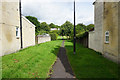
Footpath between the houses
Access off Brooklyn Road up to Rose Hill.
Image: © Bill Boaden
Taken: 25 Jul 2016
0.07 miles
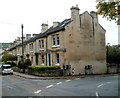
2
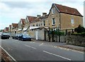
Eden Terrace, Bath
Eden Terrace is a separately-named part of Eldon Place in the Larkhall area of Bath.
Image: © Jaggery
Taken: 24 Sep 2011
0.08 miles
3

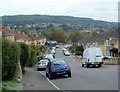
Recreation ground in Larkhall
A gap in the housing covering most of this hillside.
Image: © Bill Boaden
Taken: 25 Jul 2016
0.09 miles
4
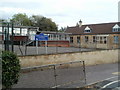
St Saviour's Church of England Junior School, Bath
Located in Brookleaze Place in the Larkhall area of Bath.
Image: © Jaggery
Taken: 24 Sep 2011
0.11 miles
5
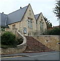
New Oriel Hall, Bath
New Oriel Hall is a community hall in Larkhall, NE Bath. Before conversion and renovation in 2004,
this was a derelict Victorian school.
Image: © Jaggery
Taken: 24 Sep 2011
0.12 miles
6
Southern section of Charlcombe Lane, Bath
Viewed from near the corner of Hill View Road.
Image: © Jaggery
Taken: 24 Sep 2011
0.12 miles
7
Avondale Buildings, Larkhall, Bath
The buildings are named, but the street is nameless.
Further ahead, out of shot, are Brookleaze Buildings.
Image: © Jaggery
Taken: 24 Sep 2011
0.12 miles
8

Bus stop on St Saviour's Road
The Linen Walk stop on a route connecting Larkhall with the centre of Bath.
Image: © Bill Boaden
Taken: 25 Jul 2016
0.13 miles
9

A Georgian postbox on St Saviour's Road
A road with a bus stop too. The brick building behind the wall is dated 1881 and was a laundry in the past.
Image: © Neil Owen
Taken: 8 Jun 2020
0.13 miles
10

The Larkhall Inn
Larkhall is far enough away from the centre of Bath to be self-sufficient in shops, including butcher's, greengrocer's, chemist, deli, theatre (!) and a large hardware shop. This public house was once a coaching inn.
Image: © HelenK
Taken: 16 Jan 2011
0.13 miles