
IMAGES TAKEN NEAR TO
Beaufort Mews, BATH, BA1 6QF
Introduction
This page details the photographs taken nearby to Beaufort Mews, BA1 6QF by members of the Geograph project.
The Geograph project started in 2005 with the aim of publishing, organising and preserving representative images for every square kilometre of Great Britain, Ireland and the Isle of Man.

There are currently over 7.5m images from over14,400 individuals and you can help contribute to the project by visiting https://www.geograph.org.uk
Image Map
Images are licensed for reuse under creativecommons.org/licenses/by-sa/2.0
Notes
- Clicking on the map will re-center to the selected point.
- The higher the marker number, the further away the image location is from the centre of the postcode.
Image Listing (80 Images Found)
Images are licensed for reuse under creativecommons.org/licenses/by-sa/2.0
Image
Details
Distance
1
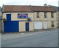
Larkhall MoT Centre, Bath
The business is in Beaufort Mews, near the corner of St Saviour's Road. One definition of "mews" is a street or yard of stabling, often converted into dwelling-houses or garages. The "street" and "garages" part of the description fit Beaufort Mews perfectly. http://www.geograph.org.uk/photo/3343295
Image: © Jaggery
Taken: 24 Sep 2011
0.01 miles
2
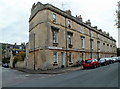
Grade II listed Victoria Place, Larkhall, Bath
Victoria Place is a separately-named row of houses extending for 55 metres along St Saviour's Road from the corner of Beaufort Place. The row, dating from the late 1830s, was Grade II listed in August 1975.
Image: © Jaggery
Taken: 24 Sep 2011
0.01 miles
3

Church of St Saviour, Bath
Alarming converging verticals for this shot of a church that straddles a gridline. The majority of the building, including the west tower, is in Image, but most of this southeastern side is in ST7666, the exception being the two bays at the left end. See Image and http://www.britishlistedbuildings.co.uk/en-443500-church-of-st-saviour-bath .
Image: © Derek Harper
Taken: 11 Feb 2012
0.02 miles
4
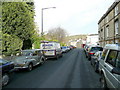
St. Saviour's Road, Larkhall
Looking north-east away from Bath city centre.
Spot the Moggie!
Image: © Jonathan Billinger
Taken: 25 Nov 2009
0.03 miles
5

St. Saviour's church, Larkhall, Bath
A large 19th century church in a suburb of the city to the north of the London Road.
The building is orientated north-east to south-west.
Image: © Jonathan Billinger
Taken: 25 Nov 2009
0.03 miles

7

Beaufort Mews, Bath
A back street off St Saviour's Road in Larkhall, meeting Beaufort Place at the T-junction at the far end. On the left is the west end of Victoria Place. an 1840s terrace described at http://www.britishlistedbuildings.co.uk/en-447291-victoria-place-1-8-bath .
Image: © Derek Harper
Taken: 11 Feb 2012
0.04 miles
8

View over Bath from the canal towpath
Image: © Dr Neil Clifton
Taken: 25 Sep 1977
0.04 miles
9

Grade II* listed Church of St Saviour, Bath
Viewed across St Saviour's Road. The cathedral-like suburban Anglican church is bordered at this end by Wallace Road and at the tower end by Holland Road. The church, aligned NNE-SSW, was built in 1829-1832 as a Gothic Revival church with both Decorated and Perpendicular architectural detailing. Grade II* listing was awarded in June 1950.
Image: © Jaggery
Taken: 24 Sep 2011
0.04 miles
10

St Saviour's Church, Bath
A view of the tower of Image from Croft Road. "A Gothic Revival church reflecting both Decorated and Perpendicular architectural detailing, built in 1829-1832" http://www.britishlistedbuildings.co.uk/en-443500-church-of-st-saviour-bath . Beyond is the Avon valley at Bathampton.
Image: © Derek Harper
Taken: 11 Feb 2012
0.04 miles