IMAGES TAKEN NEAR TO
London Road, BATH, BA1 6PZ
Introduction
This page details the photographs taken nearby to London Road, BA1 6PZ by members of the Geograph project.
The Geograph project started in 2005 with the aim of publishing, organising and preserving representative images for every square kilometre of Great Britain, Ireland and the Isle of Man.

There are currently over 7.5m images from over14,400 individuals and you can help contribute to the project by visiting https://www.geograph.org.uk
Image Map
Images are licensed for reuse under creativecommons.org/licenses/by-sa/2.0
Notes
- Clicking on the map will re-center to the selected point.
- The higher the marker number, the further away the image location is from the centre of the postcode.
Image Listing (98 Images Found)
Images are licensed for reuse under creativecommons.org/licenses/by-sa/2.0
Image
Details
Distance
2
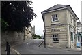
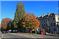
Corner of St Saviour's Road and London Road, Bath
St Saviour's Road on the left climbs away from the A4 London Road. The corner property, the office of Allen & Harris estate agents, has a frontage on London Road, where the street name sign shows Balustrade.
Image: © Jaggery
Taken: 24 Sep 2011
0.02 miles
3
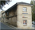
Tollhouse by the A4, London Road, Bath
Former Tollhouse, No.1, Balustrade, Walcot, BA1 6QA.
Grade II listed:-
List Entry Number: 1394167 https://historicengland.org.uk/listing/the-list/list-entry/1394167
Surveyed
Milestone Society National ID: AV.BAT03
Image: © Alan Rosevear
Taken: 30 Jan 2005
0.02 miles
4
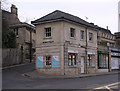
Corner of St Saviours Road and London Road
Image: © John Firth
Taken: 4 Sep 2017
0.02 miles
5
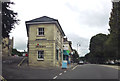
London Road, Grosvenor
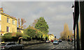
A reverse view of Image, and the sun has reappeared after heavy rain. This is the A4 and the traffic lights are at the junction with St Saviour's Road on the left. At the junction is number 1, Balustrade, a former tollhouse, shown more clearly in http://www.geograph.org.uk/gridref/ST7566?centi=ST759661 and described at https://historicengland.org.uk/listing/the-list/list-entry/1394167 . On the left is the end house of Worcester Terrace, described at https://historicengland.org.uk/listing/the-list/list-entry/1395801 ; beside it is a glimpse of Beaufort Cottage https://historicengland.org.uk/listing/the-list/list-entry/1394817 .
Image: © Derek Harper
Taken: 8 Dec 2019
0.03 miles
7
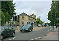
2008 : London Road at the junction with St.Saviours Road
Looking east away from Bath. St.Saviours Road is to the left.
Image: © Maurice Pullin
Taken: 4 Aug 2008
0.04 miles
8
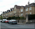
St Saviour's Terrace, Bath
Maps show the road on the left as St Saviour's Road, though the white-on-black name sign on the wall at the corner shows St Saviour's Terrace. The back-on-white name sign below the hedge on the right shows Holland Road.
Image: © Jaggery
Taken: 24 Sep 2011
0.04 miles
9
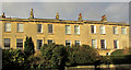
Worcester Terrace
Part of the terrace described in https://historicengland.org.uk/listing/the-list/list-entry/1395801 , seen looking left from Image
Image: © Derek Harper
Taken: 8 Dec 2019
0.05 miles
10
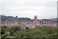
Grosvenor Terrace
Grosvenor Terrace and St Saviour's Church viewed from the Kennet and Avon Canal
Image: © Pierre Terre
Taken: 19 May 2006
0.05 miles