IMAGES TAKEN NEAR TO
Frys Leaze, BATH, BA1 6NU
Introduction
This page details the photographs taken nearby to Frys Leaze, BA1 6NU by members of the Geograph project.
The Geograph project started in 2005 with the aim of publishing, organising and preserving representative images for every square kilometre of Great Britain, Ireland and the Isle of Man.

There are currently over 7.5m images from over14,400 individuals and you can help contribute to the project by visiting https://www.geograph.org.uk
Image Map
Images are licensed for reuse under creativecommons.org/licenses/by-sa/2.0
Notes
- Clicking on the map will re-center to the selected point.
- The higher the marker number, the further away the image location is from the centre of the postcode.
Image Listing (34 Images Found)
Images are licensed for reuse under creativecommons.org/licenses/by-sa/2.0
Image
Details
Distance
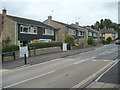
1

Charlcombe Lane houses, Bath
Houses on the east side of Charlcombe Lane, viewed from the corner of Hill View Road.
Image: © Jaggery
Taken: 24 Sep 2011
0.02 miles
2
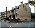
Spring Vale houses, Bath
The black-fronted houses are in Spring Vale,
a separately-named and numbered part of Charlcombe Lane.
Image: © Jaggery
Taken: 24 Sep 2011
0.04 miles
3
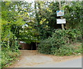
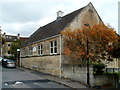
Entrance to Little Scribblers Day Nursery, Bath
Viewed from Charlcombe Lane. The nursery is in the 21st Bath (Victoria Hall) Scout Group site.
Image: © Jaggery
Taken: 24 Sep 2011
0.06 miles
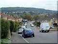
4

Recreation ground in Larkhall
A gap in the housing covering most of this hillside.
Image: © Bill Boaden
Taken: 25 Jul 2016
0.08 miles
5
Southern section of Charlcombe Lane, Bath
Viewed from near the corner of Hill View Road.
Image: © Jaggery
Taken: 24 Sep 2011
0.08 miles
6
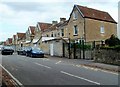
Eden Terrace, Bath
Eden Terrace is a separately-named part of Eldon Place in the Larkhall area of Bath.
Image: © Jaggery
Taken: 24 Sep 2011
0.09 miles
7
Larkhall URC Church, Bath
Larkhall United Reformed Church, part of Avondale Buildings, is located
opposite St Saviour's Church of England Nursery and Infants School.
Image: © Jaggery
Taken: 24 Sep 2011
0.12 miles
8
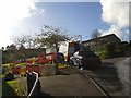
Valley View Close
This development on the edge of Larkhall doesn't yet appear on the large-scale map. The road is already being dug up but at least there is activity around the works. All too often in Bath a road is dug up, left for a while, worked on weeks later, and left for a while again before being filled in.
Image: © HelenK
Taken: 16 Oct 2012
0.13 miles
9
Avondale Buildings, Larkhall, Bath
The buildings are named, but the street is nameless.
Further ahead, out of shot, are Brookleaze Buildings.
Image: © Jaggery
Taken: 24 Sep 2011
0.13 miles
10
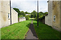
Footpath between the houses
Access off Brooklyn Road up to Rose Hill.
Image: © Bill Boaden
Taken: 25 Jul 2016
0.15 miles