IMAGES TAKEN NEAR TO
Highfields Close, STREET, BA16 9AB
Introduction
This page details the photographs taken nearby to Highfields Close, BA16 9AB by members of the Geograph project.
The Geograph project started in 2005 with the aim of publishing, organising and preserving representative images for every square kilometre of Great Britain, Ireland and the Isle of Man.

There are currently over 7.5m images from over14,400 individuals and you can help contribute to the project by visiting https://www.geograph.org.uk
Image Map
Images are licensed for reuse under creativecommons.org/licenses/by-sa/2.0
Notes
- Clicking on the map will re-center to the selected point.
- The higher the marker number, the further away the image location is from the centre of the postcode.
Image Listing (55 Images Found)
Images are licensed for reuse under creativecommons.org/licenses/by-sa/2.0
Image
Details
Distance
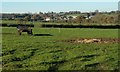
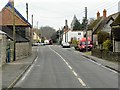
1
A row of terraced houses in Main Street Walton
Image: © David Smith
Taken: 28 Sep 2011
0.07 miles
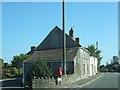
3
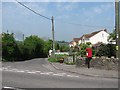
Whitley Lane
Junction with the A39, Walton.
Image: © Richard Webb
Taken: 21 Apr 2011
0.08 miles
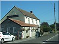
4
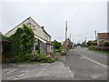
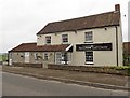
The disused Walton Gateway pub on the A39
Image: © Rob Purvis
Taken: 18 Jun 2022
0.09 miles
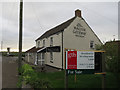
5
Closed pub and restaurant
The Brasserie and Walton Gateway closed and for sale for residential redevelopment.
Image: © Hugh Venables
Taken: 12 Apr 2017
0.10 miles
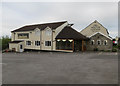
6
Walton Gateway
Formerly the 'Pike and Musket Inn' - Image
Image: © Roger Cornfoot
Taken: 29 Mar 2017
0.10 miles
7
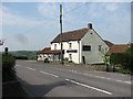
The Pike and Musket
Pub on the western end of Walton.
Image: © Richard Webb
Taken: 21 Apr 2011
0.10 miles