IMAGES TAKEN NEAR TO
Stallgrove Lane, STREET, BA16 0SS
Introduction
This page details the photographs taken nearby to Stallgrove Lane, BA16 0SS by members of the Geograph project.
The Geograph project started in 2005 with the aim of publishing, organising and preserving representative images for every square kilometre of Great Britain, Ireland and the Isle of Man.

There are currently over 7.5m images from over14,400 individuals and you can help contribute to the project by visiting https://www.geograph.org.uk
Image Map
Images are licensed for reuse under creativecommons.org/licenses/by-sa/2.0
Notes
- Clicking on the map will re-center to the selected point.
- The higher the marker number, the further away the image location is from the centre of the postcode.
Image Listing (8 Images Found)
Images are licensed for reuse under creativecommons.org/licenses/by-sa/2.0
Image
Details
Distance
1
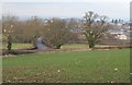
View towards Street
From the footpath past Leigh Holt Farm. The oak tree left of centre is by the junction of the Somerton Road (the B3151, seen curving away into Street) with Stallgrove Lane / Keen's Elm Lane.
Image: © Derek Harper
Taken: 12 Feb 2010
0.15 miles
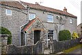
2
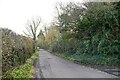
Street : Stallgrove Lane
Looking along a small lane.
Image: © Lewis Clarke
Taken: 28 Jan 2024
0.20 miles
3
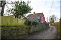
Street : Overleigh
Looking along a small lane.
Image: © Lewis Clarke
Taken: 28 Jan 2024
0.20 miles
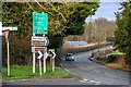
4
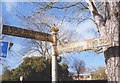
Old Direction Sign - Signpost by the B3151
Pyramid finial - 2 arms; Somerset SCC pyramid by the B3151, in parish of Street (Mendip District), Slug Hill junction with Somerton Road.
Surveyed
Milestone Society National ID: SO_ST4834A.
Image: © Milestone Society
Taken: Unknown
0.22 miles
5
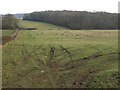
Field of sheep, Leigh Holt Farm
The public footpath runs down the left side of this field to the scene in Image The nearest ewe, her lamb close by, seem prepared to mix it with me. Leigholt Wood is in the background.
Image: © Derek Harper
Taken: 12 Feb 2010
0.22 miles
7
Street : Somerton Road B3151
Looking along Somerton Road.
Image: © Lewis Clarke
Taken: 28 Jan 2024
0.23 miles
8
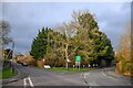
Street : Somerton Road
Somerton Road with Slugg Hill on the left. The other road in view at the junction is Higher Brooks.
Image: © Lewis Clarke
Taken: 28 Jan 2024
0.23 miles