IMAGES TAKEN NEAR TO
Briar Road, STREET, BA16 0PW
Introduction
This page details the photographs taken nearby to Briar Road, BA16 0PW by members of the Geograph project.
The Geograph project started in 2005 with the aim of publishing, organising and preserving representative images for every square kilometre of Great Britain, Ireland and the Isle of Man.

There are currently over 7.5m images from over14,400 individuals and you can help contribute to the project by visiting https://www.geograph.org.uk
Image Map
Images are licensed for reuse under creativecommons.org/licenses/by-sa/2.0
Notes
- Clicking on the map will re-center to the selected point.
- The higher the marker number, the further away the image location is from the centre of the postcode.
Image Listing (7 Images Found)
Images are licensed for reuse under creativecommons.org/licenses/by-sa/2.0
Image
Details
Distance
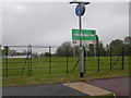
1

Street : West End
Looking down at cars waiting at the traffic lights in West End from the A39.
Image: © Lewis Clarke
Taken: 15 Jun 2012
0.08 miles
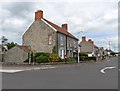
2

Street : Quarry Batch A39
A road crossing on the A39.
Image: © Lewis Clarke
Taken: 19 Jun 2023
0.10 miles
4
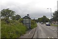
Bus shelter on Quarry Batch (A39)
The shelter is labelled: Walton Mildred Road, which refers to the road parallel to the A39 on the north
Image: © David Smith
Taken: 10 Jun 2017
0.20 miles
5

The A39 by the Clark's warehouse at Street
Image: © Ken Grainger
Taken: 1 Apr 2011
0.24 miles
7
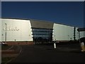
The west front of the Clarks factory lit by the afternoon sun
Image: © David Smith
Taken: 28 Sep 2011
0.25 miles