IMAGES TAKEN NEAR TO
Brutasche Terrace, STREET, BA16 0BD
Introduction
This page details the photographs taken nearby to Brutasche Terrace, BA16 0BD by members of the Geograph project.
The Geograph project started in 2005 with the aim of publishing, organising and preserving representative images for every square kilometre of Great Britain, Ireland and the Isle of Man.

There are currently over 7.5m images from over14,400 individuals and you can help contribute to the project by visiting https://www.geograph.org.uk
Image Map
Images are licensed for reuse under creativecommons.org/licenses/by-sa/2.0
Notes
- Clicking on the map will re-center to the selected point.
- The higher the marker number, the further away the image location is from the centre of the postcode.
Image Listing (261 Images Found)
Images are licensed for reuse under creativecommons.org/licenses/by-sa/2.0
Image
Details
Distance
1
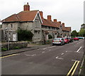
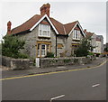
![Street houses [3]](https://s2.geograph.org.uk/geophotos/06/37/17/6371770_5c6f426a_120x120.jpg)
Street houses [3]
Brutasche Terrace, in the road of the same name, was built in 1892 by the Clark family to house their workers.
The village of Street is situated at the end of the Polden Hills on a dry spot in the Somerset Levels. There is evidence of Roman settlement. In the mid 17th century, the Society of Friends was established in Street and one of the Quaker families who settled here were the Clarks. In 1825 James Clark began the production of slippers and later shoes and boots. The business flourished under his son, William, but profits were ploughed back into employee welfare, housing and education. Much of the housing in the centre of Street was built by the company.
Image: © Michael Dibb
Taken: 21 Sep 2019
0.00 miles
2
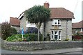
Brutasche Terrace, Street, Somerset
On the north side of Grange Road. According to one online source,
this is the only Brutasche Terrace (or Road, Street, Avenue etc) in the UK.
Image: © Jaggery
Taken: 27 Sep 2016
0.01 miles
3
![Street features [1]](https://s0.geograph.org.uk/geophotos/06/37/17/6371772_945d7ae0_120x120.jpg)
Street features [1]
A rare survival at the end of Brutasche Road is this 18th century toll gate. The gate was situated at Mead Toll House on the road between Glastonbury and Street which was part of the Wells Turnpike Trust. Listed, grade II, with details at: https://historicengland.org.uk/listing/the-list/list-entry/1058754 There is another view of the gate at Image
The village of Street is situated at the end of the Polden Hills on a dry spot in the Somerset Levels. There is evidence of Roman settlement. In the mid 17th century, the Society of Friends was established in Street and one of the Quaker families who settled here were the Clarks. In 1825 James Clark began the production of slippers and later shoes and boots. The business flourished under his son, William, but profits were ploughed back into employee welfare, housing and education. Much of the housing in the centre of Street was built by the company.
Image: © Michael Dibb
Taken: 21 Sep 2019
0.02 miles
4
![Street features [2]](https://s2.geograph.org.uk/geophotos/06/37/17/6371774_5232188d_120x120.jpg)
Street features [2]
A rare survival at the end of Brutasche Road is this 18th century toll gate. The gate was situated at Mead Toll House on the road between Glastonbury and Street which was part of the Wells Turnpike Trust. Listed, grade II, with details at: https://historicengland.org.uk/listing/the-list/list-entry/1058754
There is another view of the gate at Image
The village of Street is situated at the end of the Polden Hills on a dry spot in the Somerset Levels. There is evidence of Roman settlement. In the mid 17th century, the Society of Friends was established in Street and one of the Quaker families who settled here were the Clarks. In 1825 James Clark began the production of slippers and later shoes and boots. The business flourished under his son, William, but profits were ploughed back into employee welfare, housing and education. Much of the housing in the centre of Street was built by the company.
Image: © Michael Dibb
Taken: 21 Sep 2019
0.02 miles
5
The Acacias 1896
All the Clark's estate houses in Grange Avenue are named and dated.
Image: © Graham Horn
Taken: 10 May 2008
0.03 miles
6
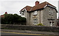
The Acacias 1892, Grange Road, Street, Somerset
One of several Grange Road houses with its name and year of construction displayed in stone.
Image: © Jaggery
Taken: 27 Sep 2016
0.03 miles
7
The Lilacs 1894
All the Clark's estate houses in Grange Avenue are named and dated.
Image: © Graham Horn
Taken: 10 May 2008
0.04 miles
8
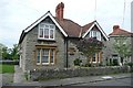
The Laburnums 1896, Grange Road, Street, Somerset
One of several Grange Road houses with its name and year of construction displayed in stone.
Image: © Jaggery
Taken: 27 Sep 2016
0.04 miles
9
Combined traffic sign facing Grange Road, Street, Somerset
The sign depicts a speed camera and shows a 20 (mph) speed limit.
Image: © Jaggery
Taken: 27 Sep 2016
0.04 miles
10
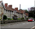
Grange Road, Street
Where many of the Clark's estate houses can be found, if you can get past the beech hedge.
Image: © Graham Horn
Taken: 10 May 2008
0.04 miles