IMAGES TAKEN NEAR TO
Guinea Lane, BATH, BA1 5NB
Introduction
This page details the photographs taken nearby to Guinea Lane, BA1 5NB by members of the Geograph project.
The Geograph project started in 2005 with the aim of publishing, organising and preserving representative images for every square kilometre of Great Britain, Ireland and the Isle of Man.

There are currently over 7.5m images from over14,400 individuals and you can help contribute to the project by visiting https://www.geograph.org.uk
Image Map
Images are licensed for reuse under creativecommons.org/licenses/by-sa/2.0
Notes
- Clicking on the map will re-center to the selected point.
- The higher the marker number, the further away the image location is from the centre of the postcode.
Image Listing (682 Images Found)
Images are licensed for reuse under creativecommons.org/licenses/by-sa/2.0
Image
Details
Distance
1
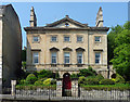
20 Roman Road, Bath
Standing proud and aloof from the street, a detached town house, quite a rarity in this area of Bath. Dated c1765, architect unknown. Palladian style, pedimented centre, rusticated basement. The pediment has a circular opening. Grade II* listed.
Image: © Stephen Richards
Taken: 25 May 2012
0.01 miles
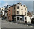
2
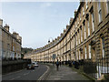
The Paragon, Bath
Elegantly curved terrace, Grade I listed
Image: © Keith Edkins
Taken: 7 Mar 2017
0.03 miles
4
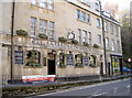
The Star
The Star Inn is one of Bath's oldest hostelries, being one of the first built in this area in 1760. It retains many old or even original features and was fortunate to survive the Baedeker raid of 1942, when several nearby buildings were damaged.
Image: © Neil Owen
Taken: 7 Jan 2014
0.03 miles
5
Challenger, Bath
The office of Challenger is on the corner of Belvedere (part of Lansdown Road)
and Guinea Lane. Challenger's business is residential property agency and consultancy.
Image: © Jaggery
Taken: 24 Sep 2011
0.03 miles
6
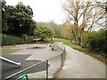
Bath, Hedgemead Park
According to a notice, created after a landslide in the 1870s removed buildings here. http://visitbath.co.uk/things-to-do/hedgemead-park-p25051
Image: © Mike Faherty
Taken: 8 Mar 2015
0.03 miles
7
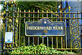
At Hedgemead Park (1)
Lansdown Road, Bath
Image: © Anthony O'Neil
Taken: 18 Mar 2023
0.03 miles
8
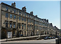
Belmont, Lansdown Road, Bath
A twenty-house terrace, some of the houses a storey higher than most of their contemporaries, but broadly similar in terms of the detail. Dated 1768-73. Unusually the architect has not been identified but several builder-architects active at the time in Bath must be candidates. Grade II listed.
The terrace stands behind a raised pavement and wrought-iron railings. Grade II listed.
Image: © Stephen Richards
Taken: 25 May 2012
0.04 miles
9
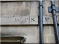
Old Boundary Marker by the A4, The Paragon
Parish Boundary Marker by the A4, in parish of Bath (Bath and North East Somerset District), The Paragon, above ground floor on fillet of No 27 Axford's Buildings.
Above Boundary Marker: SO_BHSM01pb Image
Inscription reads:-
: W.P|S.(M).P.
(Walcot Parish) (St Michael's Parish)
Axford's Buildings 22-37 are Grade II listed:
List Entry Number: 1394242 https://historicengland.org.uk/listing/the-list/list-entry/1394242
Milestone Society National ID: SO_BHWASM01pb.
Image: © Milestone Society
Taken: Unknown
0.04 miles
10
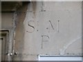
Old Boundary Marker by the A4, The Paragon, Bath
Parish Boundary Marker by the A4, in parish of Bath (Bath and North East Somerset District), The Paragon, below door lintel of No 27 Axford's buildings. Below Boundary Marker: SO_BHWASM01pb Image
Axford's Buildings 22-37 are Grade II listed:
List Entry Number: 1394242 https://historicengland.org.uk/listing/the-list/list-entry/1394242
Surveyed
Milestone Society National ID: SO_BHSM01pb
Image: © Milestone Society
Taken: Unknown
0.04 miles