IMAGES TAKEN NEAR TO
Farleigh Wick, BRADFORD-ON-AVON, BA15 2PY
Introduction
This page details the photographs taken nearby to BA15 2PY by members of the Geograph project.
The Geograph project started in 2005 with the aim of publishing, organising and preserving representative images for every square kilometre of Great Britain, Ireland and the Isle of Man.

There are currently over 7.5m images from over14,400 individuals and you can help contribute to the project by visiting https://www.geograph.org.uk
Image Map
Images are licensed for reuse under creativecommons.org/licenses/by-sa/2.0
Notes
- Clicking on the map will re-center to the selected point.
- The higher the marker number, the further away the image location is from the centre of the postcode.
Image Listing (15 Images Found)
Images are licensed for reuse under creativecommons.org/licenses/by-sa/2.0
Image
Details
Distance
1
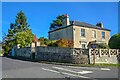
Monkton Farleigh : The Villa
A house on the road junction off Bath Road.
Image: © Lewis Clarke
Taken: 18 Oct 2022
0.00 miles
2
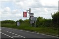
Upper or lower case in the signage?
Two signs for the King's Arms inn at Monkton Farleigh at the turning for the village on A363, one in upper case, the other in lower. The inn was formerly known as "The Muddy Duck"
Image: © David Smith
Taken: 7 Jun 2017
0.02 miles
3
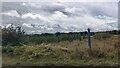
Young conifer plantation off Bath Road
Image: © Anthony Parkes
Taken: 9 Sep 2022
0.05 miles
4
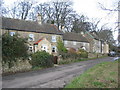
Cottages at Pinckney Green
A view looking northeast along the local access road at Pinckney Green.
Image: © Phil Williams
Taken: 17 Jan 2006
0.09 miles
5

A363, "Sally in the Wood" road, west of Farleigh Wick
The start of a gentle slope down gives drivers a view east across the Avon valley
Image: © David Smith
Taken: 7 Jun 2017
0.10 miles
6
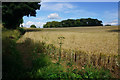
Wheat field near Bay's Farm
A footpath follows the left side of the field. The wheat appears to be not far off harvesting.
Image: © Bill Boaden
Taken: 27 Jul 2016
0.13 miles
7
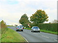
2008 : A363 near Farleigh Wick
Looking north west toward Bathford and Bath.
Image: © Maurice Pullin
Taken: 28 Oct 2008
0.13 miles
8

Bathford : Dry Arch
Entrance to Dry Arch Cottages off Sally in the Wood.
Image: © Lewis Clarke
Taken: 18 Oct 2022
0.14 miles
9
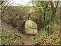
The Dry Arch
This arch is on the A363 and was built around 1795 when this new road was opened. The arch was built over the track that runs from Warleigh to Monkton Farleigh. Bathford is unusual as it has two dry arches one either end of the parish boundary.
Image: © Derek Hawkins
Taken: 11 Apr 2006
0.15 miles
10

Monkton Farleigh : Equine Centre
An equine centre off Bath Road.
Image: © Lewis Clarke
Taken: 18 Oct 2022
0.19 miles